IMAGES TAKEN NEAR TO
Brookfield, OLDHAM, OL2 7QQ
Introduction
This page details the photographs taken nearby to Brookfield, OL2 7QQ by members of the Geograph project.
The Geograph project started in 2005 with the aim of publishing, organising and preserving representative images for every square kilometre of Great Britain, Ireland and the Isle of Man.

There are currently over 7.5m images from over14,400 individuals and you can help contribute to the project by visiting https://www.geograph.org.uk
Image Map
Images are licensed for reuse under creativecommons.org/licenses/by-sa/2.0
Notes
- Clicking on the map will re-center to the selected point.
- The higher the marker number, the further away the image location is from the centre of the postcode.
Image Listing (34 Images Found)
Images are licensed for reuse under creativecommons.org/licenses/by-sa/2.0
Image
Details
Distance
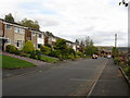
3
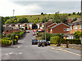
Rishworth Rise, Shaw, Oldham
Looking north west.
Image: © JThomas
Taken: 18 Oct 2018
0.05 miles
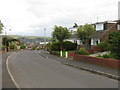
4
Rishworth Rise, Rushcroft
A newer part of the estate built up against Moss Gate Road.
Image: © Bill Boaden
Taken: 6 Aug 2011
0.05 miles

7
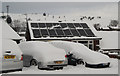
Bungalow on Trent Road, Shaw
This bungalow has sixteen solar panels fitted to the roof on which the snow has failed to settle.
Image: © michael ely
Taken: 26 Jan 2013
0.07 miles
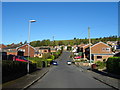
8
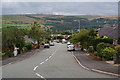
Trent Road, Rushcroft
Rushcroft is a housing estate built on a Pennine hilltop. This view looks over to Crompton Hill. Shaw is hidden in the valley bottom.
Image: © Bill Boaden
Taken: 6 Aug 2011
0.08 miles
9
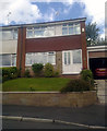
68 Rishworth Rise, Shaw and Crompton
68 Rishworth Rise, a semi-detached property in the suburban Greenhill area of Shaw and Crompton, Greater Manchester, England.
Image: © Steven Haslington
Taken: 9 Jun 2011
0.09 miles
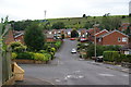
10
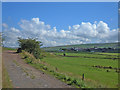
Moss Gate Road
Looking northeast towards Whitfield dairy farm from a point where Moss Gate Road ceases to border the Rushcroft area of Shaw. Crompton Moor can be seen on the skyline.
Image: © michael ely
Taken: 25 Aug 2006
0.11 miles