IMAGES TAKEN NEAR TO
Rockingham Close, OLDHAM, OL2 7LU
Introduction
This page details the photographs taken nearby to Rockingham Close, OL2 7LU by members of the Geograph project.
The Geograph project started in 2005 with the aim of publishing, organising and preserving representative images for every square kilometre of Great Britain, Ireland and the Isle of Man.

There are currently over 7.5m images from over14,400 individuals and you can help contribute to the project by visiting https://www.geograph.org.uk
Image Map
Images are licensed for reuse under creativecommons.org/licenses/by-sa/2.0
Notes
- Clicking on the map will re-center to the selected point.
- The higher the marker number, the further away the image location is from the centre of the postcode.
Image Listing (40 Images Found)
Images are licensed for reuse under creativecommons.org/licenses/by-sa/2.0
Image
Details
Distance
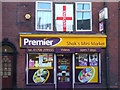
1
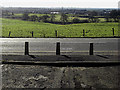
Bollards on Thornham Road, High Crompton
These bollards are at the Rockingham Close/Thornham Road junction and effectively make Rockingham Close a cul-de-sac. The view is towards Royton and Manchester.
Image: © michael ely
Taken: 30 Jan 2010
0.03 miles
2
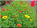
Wildflower verge
On Sherwood Way, a suburban street at High Crompton, Shaw.
Image: © michael ely
Taken: 16 Aug 2020
0.07 miles
3
Two Acre Drive, Shaw and Crompton
Two Acre Drive, a residential address in the outlying suburbs of Shaw and Crompton, in Greater Manchester.
Image: © Steven Haslington
Taken: 4 May 2011
0.09 miles
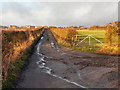
4
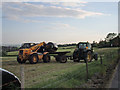
Hay Making, High Crompton
Gathering the bales of hay in the fields above Narrowgate Farm off Thornham Road.
Image: © michael ely
Taken: 4 Jun 2006
0.16 miles
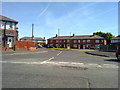
5
Local Grocery Shop, High Crompton
"Eng-er-land!"
Image: © michael ely
Taken: 4 Jun 2006
0.16 miles
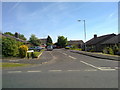
6
Low Crompton Road
Looking back towards Thornham Road at High Crompton.
Image: © David Dixon
Taken: 19 Jan 2011
0.17 miles

8
Maple Close, Shaw
A view down Maple Close, from Wood Street, in Shaw and Crompton, Greater Manchester.
Image: © Steven Haslington
Taken: 4 May 2011
0.19 miles
9

Corner Shop, High Crompton
At the corner of Rochdale Road and Marlfield Road.
Image: © michael ely
Taken: 26 Nov 2006
0.20 miles
10
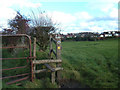
Crompton Circuit, High Crompton
Here the 11-mile circular walk around Shaw heads towards the residential area at High Crompton. The path goes over the stile then bears right towards the properties on Marlfield Road.
Image: © michael ely
Taken: 26 Nov 2006
0.20 miles