IMAGES TAKEN NEAR TO
Surrey Avenue, OLDHAM, OL2 7ET
Introduction
This page details the photographs taken nearby to Surrey Avenue, OL2 7ET by members of the Geograph project.
The Geograph project started in 2005 with the aim of publishing, organising and preserving representative images for every square kilometre of Great Britain, Ireland and the Isle of Man.

There are currently over 7.5m images from over14,400 individuals and you can help contribute to the project by visiting https://www.geograph.org.uk
Image Map
Images are licensed for reuse under creativecommons.org/licenses/by-sa/2.0
Notes
- Clicking on the map will re-center to the selected point.
- The higher the marker number, the further away the image location is from the centre of the postcode.
Image Listing (10 Images Found)
Images are licensed for reuse under creativecommons.org/licenses/by-sa/2.0
Image
Details
Distance
4
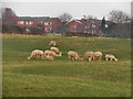
Alpacas, Low Crompton Farm
Part of the herd of alpacas, grazing in the fields of Low Crompton Farm.
Image: © David Dixon
Taken: 19 Jan 2011
0.19 miles
6
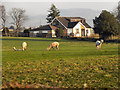
Alpacas Grazing At Low Crompton Farm
Part of the herd of alpacas, grazing in the fields of Low Crompton Farm.
Image: © David Dixon
Taken: 19 Jan 2011
0.21 miles
7
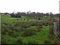
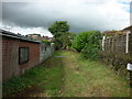
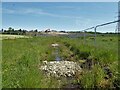
Source of the River Irk
This marshy area of land between the towns of Shaw and Royton to the north of Oldham bears several springs which constitute the source of the River Irk. The Irk runs from here in a roughly southwesterly direction for about 20km (16km as the crow flies) to Manchester city centre where it joins the River Irwell Image
Image: © Keith Williamson
Taken: 24 Nov 2005
0.22 miles
9
New source of River Irk?
View towards new housing development that might be causing more water to emerge to feed the River Irk. The traditional source of the river is behind the camera.
Image: © Kevin Waterhouse
Taken: 4 Jun 2023
0.23 miles