IMAGES TAKEN NEAR TO
Samlesbury Close, OLDHAM, OL2 7DJ
Introduction
This page details the photographs taken nearby to Samlesbury Close, OL2 7DJ by members of the Geograph project.
The Geograph project started in 2005 with the aim of publishing, organising and preserving representative images for every square kilometre of Great Britain, Ireland and the Isle of Man.

There are currently over 7.5m images from over14,400 individuals and you can help contribute to the project by visiting https://www.geograph.org.uk
Image Map
Images are licensed for reuse under creativecommons.org/licenses/by-sa/2.0
Notes
- Clicking on the map will re-center to the selected point.
- The higher the marker number, the further away the image location is from the centre of the postcode.
Image Listing (17 Images Found)
Images are licensed for reuse under creativecommons.org/licenses/by-sa/2.0
Image
Details
Distance
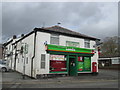
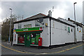
5
High Crompton Post Office
Junction of Thornham Road and Rochdale Road.
Image: © David Dixon
Taken: 17 Mar 2010
0.09 miles
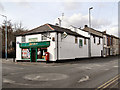
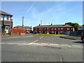
6
High Crompton Post Office
On the corner of Thornham Road and Rochdale Road (B6194).
Image: © michael ely
Taken: 6 May 2012
0.10 miles
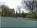
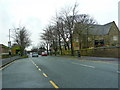
8
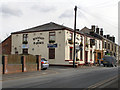
Waggon and Horses
Rochdale Road, High Crompton.
Image: © David Dixon
Taken: 17 Mar 2010
0.16 miles
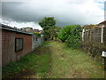
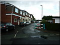
9
Maple Close, Shaw
A view down Maple Close, from Wood Street, in Shaw and Crompton, Greater Manchester.
Image: © Steven Haslington
Taken: 4 May 2011
0.17 miles