IMAGES TAKEN NEAR TO
The Crescent, OLDHAM, OL2 7BP
Introduction
This page details the photographs taken nearby to The Crescent, OL2 7BP by members of the Geograph project.
The Geograph project started in 2005 with the aim of publishing, organising and preserving representative images for every square kilometre of Great Britain, Ireland and the Isle of Man.

There are currently over 7.5m images from over14,400 individuals and you can help contribute to the project by visiting https://www.geograph.org.uk
Image Map
Images are licensed for reuse under creativecommons.org/licenses/by-sa/2.0
Notes
- Clicking on the map will re-center to the selected point.
- The higher the marker number, the further away the image location is from the centre of the postcode.
Image Listing (13 Images Found)
Images are licensed for reuse under creativecommons.org/licenses/by-sa/2.0
Image
Details
Distance

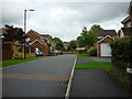
5
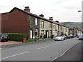
Shaw - Stone Faced Terraces
This is the upper end of Farrow Street. The major construction of the row is in brick, but original facings are all in stone, presumably to match existing, older housing stock at the time of construction.
Image: © Peter Whatley
Taken: 1 Apr 2009
0.19 miles
7
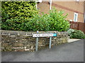
Lane Meadow, Shaw #1
Google says it Meadow Lane see #2 https://www.geograph.org.uk/photo/2062513.
Image: © Ian S
Taken: 11 Sep 2010
0.21 miles
8

Peel Street
Row of terraced houses at the end of New Barn Street, Shaw.
Image: © David Dixon
Taken: 11 May 2010
0.22 miles
9
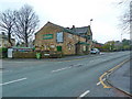
The Black Horse, Rochdale Road, Shaw
Image: © Alexander P Kapp
Taken: 21 Dec 2012
0.24 miles
10
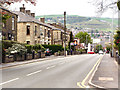
Rochdale Road
Looking downhill, along Rochdale Road (B6194), towards Shaw.
Image: © David Dixon
Taken: 11 May 2010
0.24 miles