IMAGES TAKEN NEAR TO
Loughrigg Avenue, OLDHAM, OL2 6XA
Introduction
This page details the photographs taken nearby to Loughrigg Avenue, OL2 6XA by members of the Geograph project.
The Geograph project started in 2005 with the aim of publishing, organising and preserving representative images for every square kilometre of Great Britain, Ireland and the Isle of Man.

There are currently over 7.5m images from over14,400 individuals and you can help contribute to the project by visiting https://www.geograph.org.uk
Image Map
Images are licensed for reuse under creativecommons.org/licenses/by-sa/2.0
Notes
- Clicking on the map will re-center to the selected point.
- The higher the marker number, the further away the image location is from the centre of the postcode.
Image Listing (31 Images Found)
Images are licensed for reuse under creativecommons.org/licenses/by-sa/2.0
Image
Details
Distance
1
Thornham Lane & Boundary Sign
The sign indicates entry to Royton and Oldham Metropolitan Borough Council from Rochdale. Thornham Lane's ownership seems to be variable, depending on what map is used.
Image: © Peter Whatley
Taken: 21 Jan 2010
0.04 miles
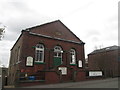
2
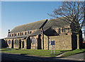
St James Church, Thornham
Situated in a residential area on Thornham Lane.
Image: © michael ely
Taken: 30 Jan 2010
0.04 miles
3
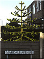
Chilean Pine, Thornham
Seen in the garden of no 44 Thornham Lane at the corner of Mardale Avenue. The sun was highlighting the distinctive foliage this afternoon.
Image: © michael ely
Taken: 30 Jan 2010
0.07 miles
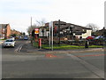
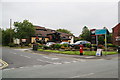
4
Summit Inn
Corner of Thornham Lane and Oldham Road.
Image: © David Dixon
Taken: 17 Mar 2010
0.08 miles

6
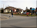
Springfield Lane, Royton, Lancashire
Looking west along this pleasant road about 1/4 mile in length which connects Shaw Road with the main Oldham to Rochdale road (A671).
Image can be seen on the right.
Image: © Dr Neil Clifton
Taken: 16 Aug 2007
0.09 miles
7
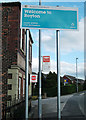
Welcome to Royton
One of the new township signs in Oldham BC's corporate colour. This is the Oldham/Rochdale borough boundary on Castleton Road near the junction with Pit Lane.
Image: © michael ely
Taken: 2 Sep 2011
0.09 miles
9
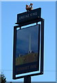
The Summit Inn
This has been fairly recently rebuilt. It is not quite at the summit of the A671 between Oldham and Rochdale, but the local area is called Summit.
Image: © Bill Boaden
Taken: 19 Jul 2011
0.10 miles