IMAGES TAKEN NEAR TO
Yarnton Close, OLDHAM, OL2 6PF
Introduction
This page details the photographs taken nearby to Yarnton Close, OL2 6PF by members of the Geograph project.
The Geograph project started in 2005 with the aim of publishing, organising and preserving representative images for every square kilometre of Great Britain, Ireland and the Isle of Man.

There are currently over 7.5m images from over14,400 individuals and you can help contribute to the project by visiting https://www.geograph.org.uk
Image Map
Images are licensed for reuse under creativecommons.org/licenses/by-sa/2.0
Notes
- Clicking on the map will re-center to the selected point.
- The higher the marker number, the further away the image location is from the centre of the postcode.
Image Listing (20 Images Found)
Images are licensed for reuse under creativecommons.org/licenses/by-sa/2.0
Image
Details
Distance
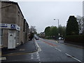
1
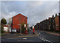
Cowlishaw Lane, Shaw #2
The lis as been painted out on the street sign.
Image]
Image: © Ian S
Taken: 11 Sep 2010
0.06 miles
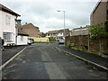
4
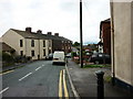
Cowlishaw Lane, Shaw #1
Google is wrong when they call it Scow Croft Lane see #2 https://www.geograph.org.uk/photo/2062467.
Image: © Ian S
Taken: 11 Sep 2010
0.07 miles
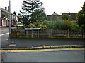
5
Shaw and Crompton Parish Boundary at Cowlishaw
The metal boundary plaque can be seen between the footpath sign and the pillar box. View looking northeast along the A663, Shaw Road. A close-up of the plaque can be seen here Image
Image: © michael ely
Taken: 6 Jan 2008
0.09 miles
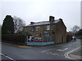
7
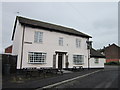
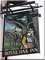
The Royal Oak Inn, Shaw
A Sam Smith's public house.
Image: © Ian S
Taken: 16 Jun 2013
0.11 miles
9
The Royal Oak Inn, Shaw
A Sam Smith's public house.
Image: © Ian S
Taken: 16 Jun 2013
0.11 miles
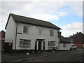
10
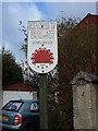
Shaw and Crompton Parish Boundary Plaque (1)
Located on the A663, Shaw Road at Cowlishaw. To see it in its geographic context see Image
Image: © michael ely
Taken: 6 Jan 2008
0.11 miles