IMAGES TAKEN NEAR TO
Daniel Street, OLDHAM, OL2 6JE
Introduction
This page details the photographs taken nearby to Daniel Street, OL2 6JE by members of the Geograph project.
The Geograph project started in 2005 with the aim of publishing, organising and preserving representative images for every square kilometre of Great Britain, Ireland and the Isle of Man.

There are currently over 7.5m images from over14,400 individuals and you can help contribute to the project by visiting https://www.geograph.org.uk
Image Map
Images are licensed for reuse under creativecommons.org/licenses/by-sa/2.0
Notes
- Clicking on the map will re-center to the selected point.
- The higher the marker number, the further away the image location is from the centre of the postcode.
Image Listing (31 Images Found)
Images are licensed for reuse under creativecommons.org/licenses/by-sa/2.0
Image
Details
Distance
1
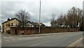
Walling for Quaker Burial Ground
At the junction for Turf Lane at Heyside
Image: © Kevin Waterhouse
Taken: 26 Feb 2023
0.03 miles
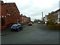
2
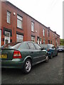
Clarence Street, Royton
A view along Clarence Street in the Heyside area of Royton, Greater Manchester, England.
Image: © Steven Haslington
Taken: 21 Jun 2011
0.11 miles
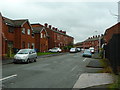
4
Row of houses on Perth Street, Oldham
Image: © Alexander P Kapp
Taken: 20 Nov 2012
0.14 miles
5
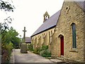
St.Marks, Heyside
Cenotaph by the side of St.Marks Church, Heyside, in the Diocese of Manchester.
Image: © Roger May
Taken: 10 Oct 2005
0.14 miles
6
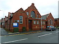
Heyside United Reformed Church, Oldham
Image: © Alexander P Kapp
Taken: 20 Nov 2012
0.15 miles
7
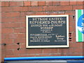
Heyside United Reformed Church, Oldham, Nameboard
Image: © Alexander P Kapp
Taken: 20 Nov 2012
0.15 miles
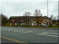
8
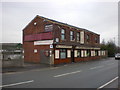
"Book your holiday here"
Healings travel agents http://www.healingscoachhire.co.uk/
Image: © Alexander P Kapp
Taken: 30 Jan 2009
0.15 miles
10
Playing Field, Heyside
This recreation area is bordered by residential development on three sides and by Blackshaw Lane Primary School on the fourth. Viewed from Perth Street.
Image: © michael ely
Taken: 10 Feb 2009
0.16 miles