IMAGES TAKEN NEAR TO
Queensgate Drive, OLDHAM, OL2 5SD
Introduction
This page details the photographs taken nearby to Queensgate Drive, OL2 5SD by members of the Geograph project.
The Geograph project started in 2005 with the aim of publishing, organising and preserving representative images for every square kilometre of Great Britain, Ireland and the Isle of Man.

There are currently over 7.5m images from over14,400 individuals and you can help contribute to the project by visiting https://www.geograph.org.uk
Image Map
Images are licensed for reuse under creativecommons.org/licenses/by-sa/2.0
Notes
- Clicking on the map will re-center to the selected point.
- The higher the marker number, the further away the image location is from the centre of the postcode.
Image Listing (18 Images Found)
Images are licensed for reuse under creativecommons.org/licenses/by-sa/2.0
Image
Details
Distance
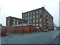
2

Thornham Mill
Almost entirely empty, but in a reasonable state of repair.
Image: © Bill Boaden
Taken: 19 Jul 2011
0.09 miles


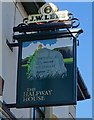
5
Halfway House
Nearly halfway between Oldham and Rochdale. Viewed across its car park.
Image: © Bill Boaden
Taken: 19 Jul 2011
0.10 miles
6

Oozewood Road, Royton
Semi-detached properties on Oozewood Road, in Thorpe - a suburban area of Royton, in Greater Manchester, England.
Image: © Steven Haslington
Taken: 27 Jun 2011
0.11 miles
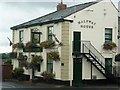
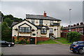
7

The Halfway House, Royton
Halfway between Roacdale and Oldham.
On Rochdale Road.
Image: © JThomas
Taken: 10 Oct 2018
0.12 miles