IMAGES TAKEN NEAR TO
Sandy Lane, OLDHAM, OL2 5RS
Introduction
This page details the photographs taken nearby to Sandy Lane, OL2 5RS by members of the Geograph project.
The Geograph project started in 2005 with the aim of publishing, organising and preserving representative images for every square kilometre of Great Britain, Ireland and the Isle of Man.

There are currently over 7.5m images from over14,400 individuals and you can help contribute to the project by visiting https://www.geograph.org.uk
Image Map
Images are licensed for reuse under creativecommons.org/licenses/by-sa/2.0
Notes
- Clicking on the map will re-center to the selected point.
- The higher the marker number, the further away the image location is from the centre of the postcode.
Image Listing (73 Images Found)
Images are licensed for reuse under creativecommons.org/licenses/by-sa/2.0
Image
Details
Distance
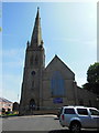
1
The Parish Church of St Paul, Royton
Image: © Alexander P Kapp
Taken: 1 Nov 2005
0.03 miles
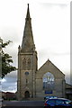
2
The Parish Church of St Paul, Royton
Image: © Alexander P Kapp
Taken: 30 Jan 2009
0.03 miles
4
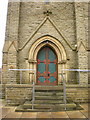
The Parish Church of St Paul, Royton, Doorway
Image: © Alexander P Kapp
Taken: 30 Jan 2009
0.04 miles
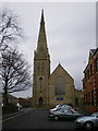
5
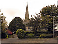
Parish Church Of St Paul, Royton
St Paul's Church, seen from Chapel Lane.
Image: © David Dixon
Taken: 28 Sep 2010
0.04 miles
6
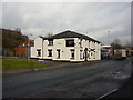
The Church Inn, Middleton Road, Royton
Image: © Alexander P Kapp
Taken: 1 Feb 2010
0.04 miles
7
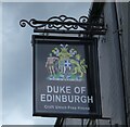
Sign of the Duke of Edinburgh
Sign for the Duke of Edinburgh Image
Image: © Gerald England
Taken: 2 Jul 2022
0.05 miles
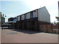
8
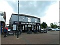
Duke of Edinburgh
A Craft Union Free House.
Image
Image: © Gerald England
Taken: 2 Jul 2022
0.05 miles
9
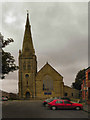
Parish Church Of St Paul, Royton
St Paul's Church, seen from Church Street
Image: © David Dixon
Taken: 28 Sep 2010
0.05 miles