IMAGES TAKEN NEAR TO
Shepherd Street, OLDHAM, OL2 5PG
Introduction
This page details the photographs taken nearby to Shepherd Street, OL2 5PG by members of the Geograph project.
The Geograph project started in 2005 with the aim of publishing, organising and preserving representative images for every square kilometre of Great Britain, Ireland and the Isle of Man.

There are currently over 7.5m images from over14,400 individuals and you can help contribute to the project by visiting https://www.geograph.org.uk
Image Map
Images are licensed for reuse under creativecommons.org/licenses/by-sa/2.0
Notes
- Clicking on the map will re-center to the selected point.
- The higher the marker number, the further away the image location is from the centre of the postcode.
Image Listing (72 Images Found)
Images are licensed for reuse under creativecommons.org/licenses/by-sa/2.0
Image
Details
Distance
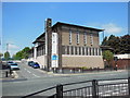
3
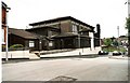
St Aidan & Oswald RC Church
Taken in Vaughan Street, looking towards Oldham Road
Image: © John C
Taken: 4 Jul 2004
0.08 miles
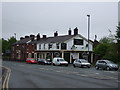

9
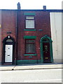
51 Shaw Road, Royton
51 Shaw Road, a terraced house on the A663 road that is typical of Royton and Greater Manchester.
Image: © Steven Haslington
Taken: 14 Jun 2011
0.13 miles