IMAGES TAKEN NEAR TO
Middleton Road, OLDHAM, OL2 5EH
Introduction
This page details the photographs taken nearby to Middleton Road, OL2 5EH by members of the Geograph project.
The Geograph project started in 2005 with the aim of publishing, organising and preserving representative images for every square kilometre of Great Britain, Ireland and the Isle of Man.

There are currently over 7.5m images from over14,400 individuals and you can help contribute to the project by visiting https://www.geograph.org.uk
Image Map
Images are licensed for reuse under creativecommons.org/licenses/by-sa/2.0
Notes
- Clicking on the map will re-center to the selected point.
- The higher the marker number, the further away the image location is from the centre of the postcode.
Image Listing (7 Images Found)
Images are licensed for reuse under creativecommons.org/licenses/by-sa/2.0
Image
Details
Distance
1
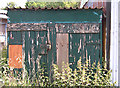
An old shed
Seen in an area of poor quality industrial units near Street Bridge.
Image: © michael ely
Taken: 16 Jun 2008
0.17 miles
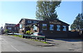

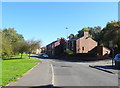
6
Street Bridge Road (B6195)
Looking north east.
Image: © JThomas
Taken: 10 Oct 2018
0.24 miles
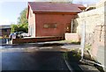
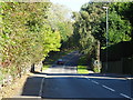
7
Middleton Road, Haggate
Looking north east on the B6195.
Image: © JThomas
Taken: 10 Oct 2018
0.25 miles