IMAGES TAKEN NEAR TO
Helmsman Lane, ROCHDALE, OL16 4PS
Introduction
This page details the photographs taken nearby to Helmsman Lane, OL16 4PS by members of the Geograph project.
The Geograph project started in 2005 with the aim of publishing, organising and preserving representative images for every square kilometre of Great Britain, Ireland and the Isle of Man.

There are currently over 7.5m images from over14,400 individuals and you can help contribute to the project by visiting https://www.geograph.org.uk
Image Map (43 Images)


Getting Data...Please wait
Leaflet Map data © OpenStreetMap
Images are licensed for reuse under creativecommons.org/licenses/by-sa/2.0
Notes
- Clicking on the map will re-center to the selected point.
- The higher the marker number, the further away the image location is from the centre of the postcode.
Image Listing (43 Images Found)
Images are licensed for reuse under creativecommons.org/licenses/by-sa/2.0
Image
Details
Distance
1
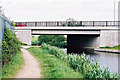
Kingsway Bridge, Rochdale Canal
Looking east. The bridge, which carries the A664 trunk, (Rochdale Bypass), has been completely rebuilt
Image: © Dr Neil Clifton
Taken: 9 Jun 2003
0.05 miles
2
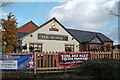
The Hornet, Kingsway Business Park
A new Hungry Horse pub has recently opened at the junction of Kingsway and Sir Isaac Newton Way.
Image: © michael ely
Taken: 10 Jan 2015
0.07 miles

4

Tour de France comes to Rochdale
Above the entrance to Gordon Rigg's Garden Centre is this yellow bicycle promoting the 2014 race. As the peloton turns left into Halifax Road at the top of the Cragg Vale climb it will have travelled 0.33 miles in Rochdale.
Image: © michael ely
Taken: 15 May 2014
0.08 miles
6
No such thing as a free lunch
A new Hungry Horse pub has recently opened at the junction of Kingsway and Sir Isaac Newton Way. This is promotional signage outside The Hornet.
Image: © michael ely
Taken: 10 Jan 2015
0.09 miles
7
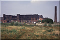
Crawford Mill, Rochdale
Thanks to Dr Neil Clifton I have been able to pin this down. It is apparently one of two mills known as "Crawford Mills". The canal is just in front of the concrete panelling and the ring road is just to the right of the shot. I photographed this at the same time as the nearby State Mill. The building was obviously in a poor state then and the satellite image shows a modern industrial building in this location.
Image: © Chris Allen
Taken: 5 May 1990
0.10 miles
8
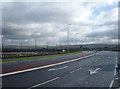
Sir Isaac Newton Way
A new road linking Kingsway to Junction 21 of the M62.
Image: © Gerald England
Taken: 10 Jun 2010
0.10 miles
10
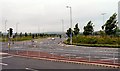
Rochdale Kingsway Business Park
This is the entrance off the A664, Kingsway, to the south of Rochdale. The 177 hectare business park is still being developed and when open will be a major plank in Rochdale's economic regeneration. Other entrances to the park are off a re-configured junction 21 on the M62 at Milnrow.
Image: © michael ely
Taken: 30 Jan 2008
0.11 miles