IMAGES TAKEN NEAR TO
Whitfield Bottoms, ROCHDALE, OL16 4LY
Introduction
This page details the photographs taken nearby to Whitfield Bottoms, OL16 4LY by members of the Geograph project.
The Geograph project started in 2005 with the aim of publishing, organising and preserving representative images for every square kilometre of Great Britain, Ireland and the Isle of Man.

There are currently over 7.5m images from over14,400 individuals and you can help contribute to the project by visiting https://www.geograph.org.uk
Image Map (Loading...)


Getting Data...Please wait
Leaflet Map data © OpenStreetMap
Images are licensed for reuse under creativecommons.org/licenses/by-sa/2.0
Notes
- Clicking on the map will re-center to the selected point.
- The higher the marker number, the further away the image location is from the centre of the postcode.
Image Listing (75 Images Found)
Images are licensed for reuse under creativecommons.org/licenses/by-sa/2.0
Image
Details
Distance
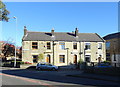
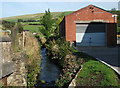
2
One of two streams at Two Bridges Road, Newhey
Image: © Ian S
Taken: 11 Sep 2010
0.06 miles
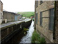
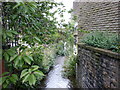
5
River Beal, Newhey
This shot is taken looking upstream from just inside the small industrial compound between Two Bridges Road and Milnrow Road.
Image: © michael ely
Taken: 15 Sep 2011
0.08 miles
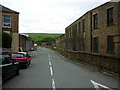
7
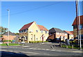
New housing on Leywood Drive, Newhey
Development off Shaw Road.
Image: © JThomas
Taken: 18 Oct 2018
0.10 miles
8
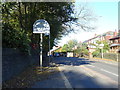
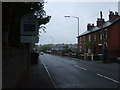
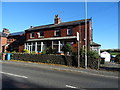
Welcome to Rochdale
Looking north west on Shaw Road (A663).
Image: © JThomas
Taken: 18 Oct 2018
0.12 miles
10
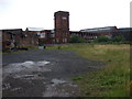
Derelict Mill, Newhey
Windowless mill near Newhey station.
Image: © Colin Pyle
Taken: 19 Aug 2008
0.12 miles