IMAGES TAKEN NEAR TO
Edmund Street, ROCHDALE, OL16 4HR
Introduction
This page details the photographs taken nearby to Edmund Street, OL16 4HR by members of the Geograph project.
The Geograph project started in 2005 with the aim of publishing, organising and preserving representative images for every square kilometre of Great Britain, Ireland and the Isle of Man.

There are currently over 7.5m images from over14,400 individuals and you can help contribute to the project by visiting https://www.geograph.org.uk
Image Map (Loading...)


Getting Data...Please wait
Leaflet Map data © OpenStreetMap
Images are licensed for reuse under creativecommons.org/licenses/by-sa/2.0
Notes
- Clicking on the map will re-center to the selected point.
- The higher the marker number, the further away the image location is from the centre of the postcode.
Image Listing (101 Images Found)
Images are licensed for reuse under creativecommons.org/licenses/by-sa/2.0
Image
Details
Distance
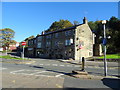
1
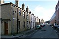
Clifton Street
A typical workers street facing industrial premises.
Image: © Bryan Tenny
Taken: 28 Feb 2011
0.02 miles
2

Vale Mill
Part of an industrial complex facing on to Clifton Street.
Image: © Bryan Tenny
Taken: 28 Feb 2011
0.03 miles
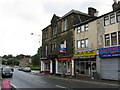
3
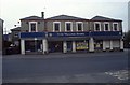
Milnrow Village Store
The right-hand portion of this building was open in 1894 as a co-operative store known as the conservative or 'Blue' store. The enlarged building has served many roles in its lifetime having been a general store and a motorcycle show room. Since this photograph was taken in 2004 it has had three more tenants and is now a carpet show room. The left-hand part of the building was a takeaway pizza restaurant in 2004 and is currently a fish and chip shop.
Image: © Bryan Tenny
Taken: Unknown
0.03 miles
4
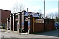
Milnrow Cars
A taxi office converted from public conveniences.
Image: © Bryan Tenny
Taken: 28 Feb 2011
0.03 miles
7
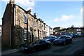
Further along Clifton Street
Typical workers terraced housing built near to the place of employment.
Image: © Bryan Tenny
Taken: 28 Feb 2011
0.04 miles
8
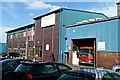
Holroyds works
An industrial building on Harbour Lane North in Milnrow.
Image: © Bryan Tenny
Taken: 16 Mar 2011
0.04 miles
9
Milnrow Reform Club
Milnrow used to be an urban district, with the power to raise its own rate, and independent within Lancashire County. Of course, that all went with the infamous Local Government act of 1974. Now Milnrow is just a small part of the enormous Metropolitan Borough of Rochdale. It's not likely that institutions like the Reform Club will ever exist again.
Image: © Dr Neil Clifton
Taken: 3 Oct 2009
0.04 miles
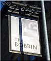
10
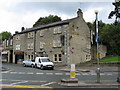
The 'Tim Bobbin', Dale Street, Milnrow
At the bottom of Kiln Lane. They seem to have dropped the 'Tim' from the name, but it is retained by the name on the bus stop opposite. Tim Bobbin was a local dialect poet and writer, whose real name was, I think, John Collier.
Image: © Dr Neil Clifton
Taken: 3 Oct 2009
0.04 miles