IMAGES TAKEN NEAR TO
Stott Street, ROCHDALE, OL16 4EN
Introduction
This page details the photographs taken nearby to Stott Street, OL16 4EN by members of the Geograph project.
The Geograph project started in 2005 with the aim of publishing, organising and preserving representative images for every square kilometre of Great Britain, Ireland and the Isle of Man.

There are currently over 7.5m images from over14,400 individuals and you can help contribute to the project by visiting https://www.geograph.org.uk
Image Map (Loading...)


Getting Data...Please wait
Leaflet Map data © OpenStreetMap
Images are licensed for reuse under creativecommons.org/licenses/by-sa/2.0
Notes
- Clicking on the map will re-center to the selected point.
- The higher the marker number, the further away the image location is from the centre of the postcode.
Image Listing (58 Images Found)
Images are licensed for reuse under creativecommons.org/licenses/by-sa/2.0
Image
Details
Distance
1
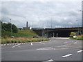
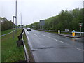
Roundabout, A663, Elizabethan Way, Milnrow
Works are taking place to enlarge this roundabout as part of the M62, Junction 21 improvements associated with the Kingsway Business Park development
Image: © michael ely
Taken: 18 Feb 2007
0.04 miles
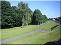
2
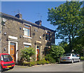
Ladyhouse Lane, Milnrow
Ladyhouse Lane in the Ladyhouse area of Milnrow, Greater Manchester.
Image: © Steven Haslington
Taken: 3 Jun 2011
0.05 miles
3
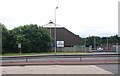
Milnrow Compound
The Milnrow Compound of the Highways Agency. This facility is a base for Traffic Officers, workmen, snowploughs and gritting services for the M62 motorway, based in Milnrow, Greater Manchester.
Image: © Steven Haslington
Taken: 12 Jul 2016
0.07 miles
4
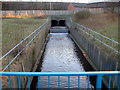
River Beal
Seeing the light in between the culverts of the M62 and the Elizabethan Way.
Image: © Paul Hogg
Taken: 10 Feb 2007
0.07 miles
5
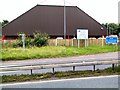
Salt Cellar
The Highways Agency has many of these huge barns adjacent to all our Motorways to store rock salt for gritting in winter. This one is by junction 21 of the M62, at Newhey near Rochdale.
Image: © Roger May
Taken: 27 Aug 2005
0.07 miles
6
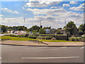
Elizabethan Way Roundabout
Looking over the roundabout on Elizabethan way towards the A6199, Sir Isaac Newton Way (Kingsway Park link road and M62 junction 21 slip roads).
Image: © David Dixon
Taken: 16 Jun 2010
0.07 miles
9
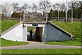
Subway short cut
This subway under Elizabethan Way allows pedestrians to get from one part of Ladyhouse Lane to the other. Ladyhouse Lane was cut when Elizabethan Way was constructed in the late 1960s early 1970s as a link road to the M62 Motorway which was constructed in the same period.
Image: © Bryan Tenny
Taken: 28 Mar 2011
0.09 miles