IMAGES TAKEN NEAR TO
The Cray, ROCHDALE, OL16 4DP
Introduction
This page details the photographs taken nearby to The Cray, OL16 4DP by members of the Geograph project.
The Geograph project started in 2005 with the aim of publishing, organising and preserving representative images for every square kilometre of Great Britain, Ireland and the Isle of Man.

There are currently over 7.5m images from over14,400 individuals and you can help contribute to the project by visiting https://www.geograph.org.uk
Image Map (Loading...)


Getting Data...Please wait
Leaflet Map data © OpenStreetMap
Images are licensed for reuse under creativecommons.org/licenses/by-sa/2.0
Notes
- Clicking on the map will re-center to the selected point.
- The higher the marker number, the further away the image location is from the centre of the postcode.
Image Listing (25 Images Found)
Images are licensed for reuse under creativecommons.org/licenses/by-sa/2.0
Image
Details
Distance
2
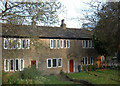
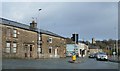
Stone cottages, Milnrow
This attractive row of cottages is at the very end of Dale St - Milnrow's main shopping street. Although rural in character they couldn't be closer to all amenities.
Image: © michael ely
Taken: 25 Nov 2005
0.17 miles
3
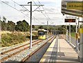
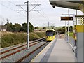
Metrolink Station, Kingsway Business Park
The stop at Kingsway Business Park also serves the housing on the other side of the line. The two platforms are offset. Here, Metrolink tram 3016 is leaving for Rochdale.
Image: © David Dixon
Taken: 6 Oct 2013
0.18 miles
4
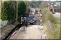
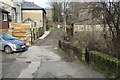
Getting there
This picture shows the continuing work on the conversion of the former 'Oldham Loop' railway line to the Manchester Metrolink tramway. Looking towards Rochdale from the Elizabethan Way road bridge it is obvious from the bridge in the distance how the track bed has been widened to accommodate cable ducting.
Image: © Bryan Tenny
Taken: 28 Mar 2011
0.18 miles
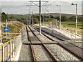
6

Pond at Kingsway Business Park Site
Kingsway Business Park http://www.kingsway-business-park.com/ is an ambitious development on a 170 hactare (420 acre) site located adjacent to and with direct access onto the M62 at Junction 21. The site is still under development, this view is from the new Metrolink Station.
Image: © David Dixon
Taken: 6 Oct 2013
0.18 miles
7
Whitehead Street, Milnrow
Whitehead Street in Milnrow, Greater Manchester, England.
Image: © Steven Haslington
Taken: 3 Jun 2011
0.18 miles
8
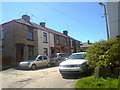
Shore Street
An unadopted street near the centre of Milnrow.
Image: © Bryan Tenny
Taken: 17 Feb 2011
0.18 miles
10
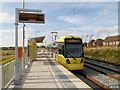
Foot Crossing at Kingsway Business Park Metrolink Stop
The two platforms at Kingsway Park are staggered, with a foot crossing between them. this crossing forms part of a footpath between the business park and the houses on Turbary Walk/Leyfield Road.
This view is looking from the inward (Manchester) platform towards the outward (Rochdale) platform.
Image: © David Dixon
Taken: 6 Oct 2013
0.19 miles