IMAGES TAKEN NEAR TO
Yeomans Close, ROCHDALE, OL16 3UP
Introduction
This page details the photographs taken nearby to Yeomans Close, OL16 3UP by members of the Geograph project.
The Geograph project started in 2005 with the aim of publishing, organising and preserving representative images for every square kilometre of Great Britain, Ireland and the Isle of Man.

There are currently over 7.5m images from over14,400 individuals and you can help contribute to the project by visiting https://www.geograph.org.uk
Image Map (Loading...)


Getting Data...Please wait
Leaflet Map data © OpenStreetMap
Images are licensed for reuse under creativecommons.org/licenses/by-sa/2.0
Notes
- Clicking on the map will re-center to the selected point.
- The higher the marker number, the further away the image location is from the centre of the postcode.
Image Listing (69 Images Found)
Images are licensed for reuse under creativecommons.org/licenses/by-sa/2.0
Image
Details
Distance
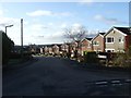
1
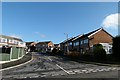
Turnough Road
Part of a 1970s housing estate built on the site of Ashes farm Milnrow.
Image: © Bryan Tenny
Taken: 16 Feb 2011
0.02 miles
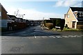
2
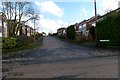
Yoemans Close
A 1970s housing estate built on the site of Ashes farm.
Image: © Bryan Tenny
Taken: 16 Feb 2011
0.02 miles
3
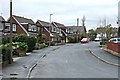
Eafield Avenue
A street in the form of a loop. This picture was taken at its junction with Eafield Close.
Image: © Bryan Tenny
Taken: 5 Apr 2011
0.04 miles
4
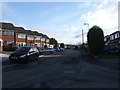
Croft Head Drive Milnrow
Another example of late 1970's housing built on the former Ashes farm
Image: © Bryan Tenny
Taken: 30 Nov 2009
0.05 miles
5
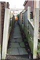
A short cut
An alley linking Roads Ford Avenue with Croft Head Drive on the 1970s housing estate built on the site of Ashes Farm.
Image: © Bryan Tenny
Taken: 17 Feb 2011
0.05 miles
6
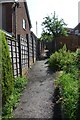
Alley to Croft Head Drive
This alley runs from Stock Grove to Croft Head Drive on the 1970s Ashes Farm estate in Milnrow
Image: © Bryan Tenny
Taken: Unknown
0.06 miles
7
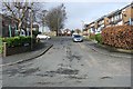
Roads Ford Avenue
Part of the 1970s housing estate built on the site of Ashes farm.
Image: © Bryan Tenny
Taken: 17 Feb 2011
0.07 miles
8
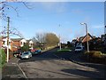
Croft Head Drive Milnrow
Another view of Croft Head Drive looking towards the edge of the built up area
Image: © Bryan Tenny
Taken: 30 Nov 2009
0.08 miles
9
Weir Rd Milnrow
An example of late 1970's housing built on the site of Ashes Farm
Image: © Bryan Tenny
Taken: 30 Nov 2009
0.09 miles
10
Sandstone Road
Part of a 1970s housing estate built on the site of Ashes farm Milnrow.
Image: © Bryan Tenny
Taken: 16 Feb 2011
0.09 miles