IMAGES TAKEN NEAR TO
Highbank Road, ROCHDALE, OL16 3RS
Introduction
This page details the photographs taken nearby to Highbank Road, OL16 3RS by members of the Geograph project.
The Geograph project started in 2005 with the aim of publishing, organising and preserving representative images for every square kilometre of Great Britain, Ireland and the Isle of Man.

There are currently over 7.5m images from over14,400 individuals and you can help contribute to the project by visiting https://www.geograph.org.uk
Image Map (Loading...)


Getting Data...Please wait
Leaflet Map data © OpenStreetMap
Images are licensed for reuse under creativecommons.org/licenses/by-sa/2.0
Notes
- Clicking on the map will re-center to the selected point.
- The higher the marker number, the further away the image location is from the centre of the postcode.
Image Listing (69 Images Found)
Images are licensed for reuse under creativecommons.org/licenses/by-sa/2.0
Image
Details
Distance
1
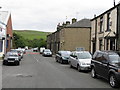
Haugh Fold, Newhey
A view of Haugh Fold, from Haugh Lane in Newhey, Greater Manchester. Haugh is former hamlet by the foothills of the South Pennines, but now an outlying suburban area of Newhey. Running through Haugh is Haugh Brook.
Image: © Steven Haslington
Taken: 16 May 2011
0.04 miles

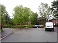
3
Bethany Lane, Haugh
A view up Bethany Lane in the Haugh area of Newhey, in Greater Manchester, England.
Image: © Steven Haslington
Taken: 16 May 2011
0.06 miles
4
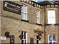
The Cedar Tree, Haugh, Newhey
In the last few years this pub has been The Wheatsheaf, The Sheaf and now The Cedar Tree at the Sheaf. The original Cedar Tree restaurant was a very small but fine dining establishment on Huddersfield Road, Newhey.
Image: © michael ely
Taken: 22 Oct 2011
0.07 miles

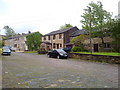
6
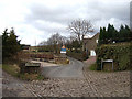
The Haugh, Newhey
The Haugh is a cluster of cottages on the eastern edge of Newhey. The tarmac lane is Bethany Lane, a narrow back road leading to the A640 near Ogden.
Image: © michael ely
Taken: 7 Mar 2008
0.07 miles
7
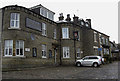
The Sheaf, Haugh Fold, Newhey
On the corner of Two Bridges Road and Haugh Lane. This pub was formerly known as The Wheatsheaf.
Image: © michael ely
Taken: 1 Mar 2010
0.08 miles
8

Cyclists clear off!
This is a private road and a public footpath. And of course, cyclists aren't welcome. The sign has been erected at the Haugh end of the track.
Image: © michael ely
Taken: 3 Apr 2010
0.09 miles
9
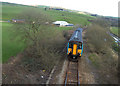
Approaching Newhey
This is the railway line from Manchester to Rochdale via Oldham Mumps. Shot taken of an approaching train from the bridge on Two Bridges Road, about 300 metres southeast of Newhey station.
Image: © michael ely
Taken: 2 Apr 2008
0.11 miles