IMAGES TAKEN NEAR TO
Bradley Lane, ROCHDALE, OL16 3QT
Introduction
This page details the photographs taken nearby to Bradley Lane, OL16 3QT by members of the Geograph project.
The Geograph project started in 2005 with the aim of publishing, organising and preserving representative images for every square kilometre of Great Britain, Ireland and the Isle of Man.

There are currently over 7.5m images from over14,400 individuals and you can help contribute to the project by visiting https://www.geograph.org.uk
Image Map (Loading...)


Getting Data...Please wait
Leaflet Map data © OpenStreetMap
Images are licensed for reuse under creativecommons.org/licenses/by-sa/2.0
Notes
- Clicking on the map will re-center to the selected point.
- The higher the marker number, the further away the image location is from the centre of the postcode.
Image Listing (77 Images Found)
Images are licensed for reuse under creativecommons.org/licenses/by-sa/2.0
Image
Details
Distance
1
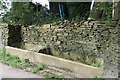
Horse Troughs
Situated in the hamlet of Bradley above Newhey, horse troughs were once a common feature of the rural landscape
Image: © Bryan Tenny
Taken: 12 Sep 2006
0.03 miles
2
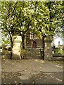
Newhey Church Gates
The Parish Church of St Thomas, Newhey, is a Grade II Listed Building (English Heritage ID:213422 http://www.britishlistedbuildings.co.uk/en-213422-church-of-st-thomas-new-hey- British Listed Buildings). It dates from 1876-7.
Image: © David Dixon
Taken: 6 Oct 2013
0.08 miles
3
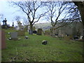
St Thomas' Church, Newhey, Graveyard
Image: © Alexander P Kapp
Taken: 30 Jan 2009
0.08 miles
4
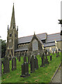
St Thomas' Church, Newhey
Undergoing a few repairs.
Image: © Alexander P Kapp
Taken: 30 Jan 2009
0.08 miles
5
St Thomas's Church, Newhey
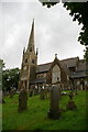
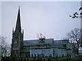
The Parish Church of St Thomas at Newhey dates from 1876-6. It is a Grade II Listed Building (English Heritage ID:213422 http://www.britishlistedbuildings.co.uk/en-213422-church-of-st-thomas-new-hey- British Listed Buildings). The 4-stage tower is topped by a broach spire which has lucarnes and a weather-cock and is set back behind an enriched parapet.
Image: © David Dixon
Taken: 6 Oct 2013
0.08 miles
6
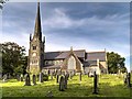
St. Thomas's Church, Newhey
Worshippers here face a stiff climb from the main road. The spire of St. Thomas's is a local landmark.
Image: © Dr Neil Clifton
Taken: 18 Sep 2009
0.08 miles
7
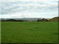
View northwest from Bradley Lane, Newhey
Milnrow and Rochdale in the middle distance, with construction just started of the Scout Moor wind farm above Rochdale on the West Pennine Moors.
Image (1) from the Newhey to Marsden station to station walk.
Image: © John Topping
Taken: 1 Oct 2009
0.09 miles
8
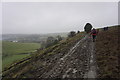
Muddy track above Newhey
The M62 can be seen down to the left. It is a grey drizzly morning.
Image: © Bill Boaden
Taken: 28 Feb 2015
0.09 miles