IMAGES TAKEN NEAR TO
Woodside, ROCHDALE, OL16 3QQ
Introduction
This page details the photographs taken nearby to Woodside, OL16 3QQ by members of the Geograph project.
The Geograph project started in 2005 with the aim of publishing, organising and preserving representative images for every square kilometre of Great Britain, Ireland and the Isle of Man.

There are currently over 7.5m images from over14,400 individuals and you can help contribute to the project by visiting https://www.geograph.org.uk
Image Map (Loading...)


Getting Data...Please wait
Leaflet Map data © OpenStreetMap
Images are licensed for reuse under creativecommons.org/licenses/by-sa/2.0
Notes
- Clicking on the map will re-center to the selected point.
- The higher the marker number, the further away the image location is from the centre of the postcode.
Image Listing (35 Images Found)
Images are licensed for reuse under creativecommons.org/licenses/by-sa/2.0
Image
Details
Distance
1

Stile near Rough Bank
This one is complicated. You have to remove the two mesh panels; they slide out easily, then climb over, hoping that the decaying wood does not give way. Finally replace the panels to stop sheep from getting through.
Image: © Humphrey Bolton
Taken: 20 Apr 2011
0.10 miles
3

Path through the wood
A public footpath runs along the top of the wood, but is rather indistinct. This point is as far as you can go on the top of the ridge. On looking down into the wood, another faint path can be seen, which is the one that leads down into the valley.
Image: © Humphrey Bolton
Taken: 20 Apr 2011
0.10 miles
4

Track beside Piethorne Brook
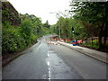
The stone setts and general appearance of this area suggest that there was industry here, and an old map shows Wood Mill. A pipe can be seen crossing the stream, and behind it a machine has an enormous drill for piling; it is on the A640.
Image: © Humphrey Bolton
Taken: 20 Apr 2011
0.11 miles
5

Broken stile
No difficulty in negotiating this one!
Image: © Humphrey Bolton
Taken: 20 Apr 2011
0.11 miles
6
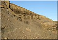
Moy Hill Quarry
This quarry in Newhey was the source of material for Newhey bricks. Disused for a long time there have been proposals to re-open it. However, although the company, Brock PLC, installed some security fencing there has been no further activity for several years.
Image: © Bryan Tenny
Taken: 26 Dec 2008
0.12 miles
8
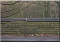
Peppermint Bridge, Newhey
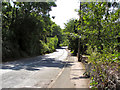
A stone bridge on the A640, Huddersfield Road, spanning the stream that runs down the Ogden Valley. This new bridge celebrated its centenary this year.
Image: © michael ely
Taken: 8 Dec 2006
0.14 miles
10

Weirs on Piethorne Brook, Newhey
These are downstream of the dyeworks, and might have provided a water supply for Wood Mill, long since demolished.
Image: © Humphrey Bolton
Taken: 20 Apr 2011
0.16 miles