IMAGES TAKEN NEAR TO
Major Street, ROCHDALE, OL16 3JZ
Introduction
This page details the photographs taken nearby to Major Street, OL16 3JZ by members of the Geograph project.
The Geograph project started in 2005 with the aim of publishing, organising and preserving representative images for every square kilometre of Great Britain, Ireland and the Isle of Man.

There are currently over 7.5m images from over14,400 individuals and you can help contribute to the project by visiting https://www.geograph.org.uk
Image Map (125 Images)


Getting Data...Please wait
Leaflet Map data © OpenStreetMap
Images are licensed for reuse under creativecommons.org/licenses/by-sa/2.0
Notes
- Clicking on the map will re-center to the selected point.
- The higher the marker number, the further away the image location is from the centre of the postcode.
Image Listing (125 Images Found)
Images are licensed for reuse under creativecommons.org/licenses/by-sa/2.0
Image
Details
Distance
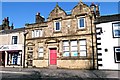
1
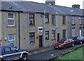
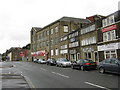
Major Street, Milnrow
A narrow street, made even narrower by on-street parking, that runs parallel with Dale Street. These terraced properties are on the south side of the street. Opposite is local authority-built housing. The three-bedroomed house for sale is on the market (a falling market) at around £72,000 in December 2008.
Image: © michael ely
Taken: 14 Dec 2008
0.02 miles
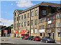
2
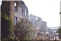
Milnrow Cotton Mill :1992
The remains of Milnrow Cotton Mill after a devastating fire in 1992. The mill had been used as a shopping complex. It was later re-built, with only the front of the original building remaining.
Image: © Paul Hogg
Taken: Unknown
0.02 miles
3
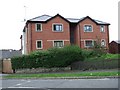
New Apartments on Smith Hill
These apartments are extension of the development of the former Milnrow Spinning Company site on Chapel gate. They occupy what was open land off Smith Hill originally part of one of the two Holts farms which now form the Holts Estate.
Image: © Bryan Tenny
Taken: Unknown
0.03 miles
4
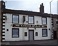
Another closed pub
The Woolpack closed in 2003 is now a day centre for people with special needs
Image: © Bryan Tenny
Taken: Unknown
0.03 miles
5
No more banking
This building is the site of the former NatWest Bank on Dale Street and is now used for other commercial purposes.
Image: © Bryan Tenny
Taken: 7 Mar 2011
0.04 miles
6
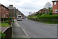
Major Street
Mix of old council housing and older terraced housing. Viewed from Smith Hill.
Image: © Bryan Tenny
Taken: 19 Apr 2011
0.04 miles
7
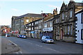
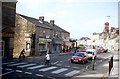
Dale Street, Milnrow
The building on the right used to be a NatWest Bank. There are now no banks left in the village.
Image: © Bill Boaden
Taken: 27 Mar 2010
0.04 miles
10
Dale Street, Milnrow : 1992
A view down the main road of Milnrow in 1992. On the right is Milnrow Cotton Mill just days before it was destroyed by fire. Across the road is the old co-op building which has now been demolished and a block of flats and shops has been built on the site. The zebra crossing in the foreground is now a pelican crossing.
Image: © Paul Hogg
Taken: Unknown
0.05 miles