IMAGES TAKEN NEAR TO
Kiln Lane, ROCHDALE, OL16 3HN
Introduction
This page details the photographs taken nearby to Kiln Lane, OL16 3HN by members of the Geograph project.
The Geograph project started in 2005 with the aim of publishing, organising and preserving representative images for every square kilometre of Great Britain, Ireland and the Isle of Man.

There are currently over 7.5m images from over14,400 individuals and you can help contribute to the project by visiting https://www.geograph.org.uk
Image Map
Images are licensed for reuse under creativecommons.org/licenses/by-sa/2.0
Notes
- Clicking on the map will re-center to the selected point.
- The higher the marker number, the further away the image location is from the centre of the postcode.
Image Listing (47 Images Found)
Images are licensed for reuse under creativecommons.org/licenses/by-sa/2.0
Image
Details
Distance
1
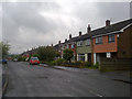
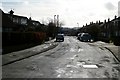
Alpine Drive, Milnrow
Alpine Drive in Milnrow, Greater Manchester, is part of a suburban housing estate on the north eastern side of Milnrow.
Image: © Steven Haslington
Taken: 26 May 2011
0.03 miles
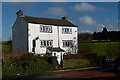
2
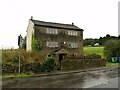
Hollin Hall, Kiln Lane, Milnrow
Probably 18th century, showing the typical stone-mullioned windows of the area and period.
Image: © Alan Murray-Rust
Taken: 1 Oct 2023
0.04 miles
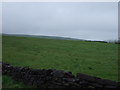
3
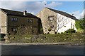
Lower Crows Nest farm
Old farm buildings converted to housing
Image: © Bryan Tenny
Taken: 16 Feb 2011
0.04 miles
4
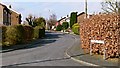
Cotswold Crescent
Part of a 1960s housing estate built on the site of Lowhouse farm.
Image: © Bryan Tenny
Taken: 4 Mar 2011
0.05 miles
5
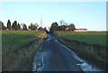
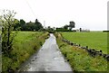
Milnrow - the edge of suburbia
This is a view eastwards at the end of Kiln Lane. The lane leads to Tunshill Golf Club and then as a rough track/bridleway into the Ogden valley and beyond.
Image: © michael ely
Taken: 24 Nov 2005
0.05 miles
7
Hollin Hall
Old building converted for modern use.
Image: © Bryan Tenny
Taken: 16 Feb 2011
0.06 miles
8
Alpine Drive
Part of a housing estate built on the site of Low House farm in Milnrow in the late 1960s. The builder erected several estates in the districts around Rochdale,giving them all similar street names.
Image: © Bryan Tenny
Taken: 16 Feb 2011
0.07 miles
9
Milnrow - the edge of suburbia
Recreating this 'First' for the square https://www.geograph.org.uk/photo/83588
Image: © Alan Murray-Rust
Taken: 1 Oct 2023
0.07 miles
10
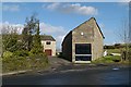
Lower Crows Nest farm another view
A private garage converted from a barn at Lower Crows nest farm.
Image: © Bryan Tenny
Taken: 16 Feb 2011
0.07 miles