IMAGES TAKEN NEAR TO
Stanneybrook Close, ROCHDALE, OL16 2YH
Introduction
This page details the photographs taken nearby to Stanneybrook Close, OL16 2YH by members of the Geograph project.
The Geograph project started in 2005 with the aim of publishing, organising and preserving representative images for every square kilometre of Great Britain, Ireland and the Isle of Man.

There are currently over 7.5m images from over14,400 individuals and you can help contribute to the project by visiting https://www.geograph.org.uk
Image Map (Loading...)


Getting Data...Please wait
Leaflet Map data © OpenStreetMap
Images are licensed for reuse under creativecommons.org/licenses/by-sa/2.0
Notes
- Clicking on the map will re-center to the selected point.
- The higher the marker number, the further away the image location is from the centre of the postcode.
Image Listing (8 Images Found)
Images are licensed for reuse under creativecommons.org/licenses/by-sa/2.0
Image
Details
Distance
1
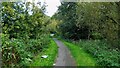
Cycleway along the Stanney Brook
This is part of the route from Healey Dell to Rochdale Canal that is largely traffic free and helped by a footbridge across the River Roch behind the camera
Image: © Kevin Waterhouse
Taken: 27 Sep 2022
0.06 miles
2
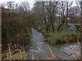
Hey Brook
Hey Brook at the confluence with the River Roch.
Image: © Paul Hogg
Taken: 24 Nov 2007
0.15 miles
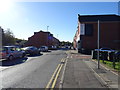
3
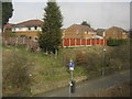
Houses alongside Belfield Lane, Newbold
Image: © Peter Whatley
Taken: 25 Mar 2011
0.21 miles
4
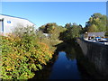
The River Roch
View north east from the bridge on Belford Road.
Image: © JThomas
Taken: 18 Oct 2018
0.21 miles
5
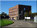
Unique Enterprise Centre
Home to the Kashmir Youth Project.
Image: © JThomas
Taken: 18 Oct 2018
0.22 miles
6
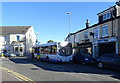
Stuck bus on Entwisle Road
Someones inconsiderate parking was causing traffic chaos.
Image: © JThomas
Taken: 18 Oct 2018
0.22 miles
8
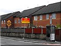
Electioneering 2010
Political neighbours on Entwistle Street, Wardleworth
Image: © Peter Thwaite
Taken: 1 May 2010
0.25 miles