IMAGES TAKEN NEAR TO
Higher Wheat Lane, ROCHDALE, OL16 2YF
Introduction
This page details the photographs taken nearby to Higher Wheat Lane, OL16 2YF by members of the Geograph project.
The Geograph project started in 2005 with the aim of publishing, organising and preserving representative images for every square kilometre of Great Britain, Ireland and the Isle of Man.

There are currently over 7.5m images from over14,400 individuals and you can help contribute to the project by visiting https://www.geograph.org.uk
Image Map (6 Images)


Getting Data...Please wait
Leaflet Map data © OpenStreetMap
Images are licensed for reuse under creativecommons.org/licenses/by-sa/2.0
Notes
- Clicking on the map will re-center to the selected point.
- The higher the marker number, the further away the image location is from the centre of the postcode.
Image Listing (6 Images Found)
Images are licensed for reuse under creativecommons.org/licenses/by-sa/2.0
Image
Details
Distance
1
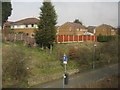
Houses alongside Belfield Lane, Newbold
Image: © Peter Whatley
Taken: 25 Mar 2011
0.11 miles
2
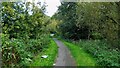
Cycleway along the Stanney Brook
This is part of the route from Healey Dell to Rochdale Canal that is largely traffic free and helped by a footbridge across the River Roch behind the camera
Image: © Kevin Waterhouse
Taken: 27 Sep 2022
0.20 miles
4
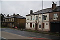
The Fox Inn, Milnrow Road, Rochdale
Boarded up, but I don't know whether this is temporary or not.
Image: © Bill Boaden
Taken: 13 Sep 2010
0.22 miles
5
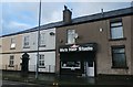
Mo'z Hair Studio and Terraced Row - Newbold
Image: © Anthony Parkes
Taken: 15 Jan 2016
0.22 miles
6
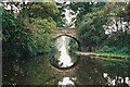
Belfield Bridge, Rochdale Canal, Lancashire
The bridge is seen from the north, with Coppy Bridge just visible in the far distance
Image: © Dr Neil Clifton
Taken: 29 Sep 2002
0.23 miles