IMAGES TAKEN NEAR TO
Nile Street, ROCHDALE, OL16 2NF
Introduction
This page details the photographs taken nearby to Nile Street, OL16 2NF by members of the Geograph project.
The Geograph project started in 2005 with the aim of publishing, organising and preserving representative images for every square kilometre of Great Britain, Ireland and the Isle of Man.

There are currently over 7.5m images from over14,400 individuals and you can help contribute to the project by visiting https://www.geograph.org.uk
Image Map
Images are licensed for reuse under creativecommons.org/licenses/by-sa/2.0
Notes
- Clicking on the map will re-center to the selected point.
- The higher the marker number, the further away the image location is from the centre of the postcode.
Image Listing (30 Images Found)
Images are licensed for reuse under creativecommons.org/licenses/by-sa/2.0
Image
Details
Distance
1

Jalalia Jame mosque, Rochdale
This mosque, situated off Entwistle Rd, is in the heart of one of Rochdale's Bangladeshi communities.
Image: © michael ely
Taken: 25 Nov 2005
0.07 miles
2
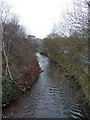
River Roch from John Street bridge
Image: © Alexander P Kapp
Taken: 25 Jan 2010
0.10 miles
3
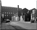
West end of Ramsay Street, Rochdale, Lancashire
This shows the end of Ramsay Street where it makes a T-junction with George Street. On the right is a mineral water factory, and across the end, actually on George Street, is the five-storey Jennings Mill (cotton and cotton waste).
Image: © Dr Neil Clifton
Taken: 15 Sep 1979
0.12 miles
4
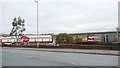
Retail park, Molesworth Street, Rochdale
TK-Maxx and Home Bargains are the principal retailers.
Image: © Stephen Craven
Taken: 26 Nov 2018
0.13 miles
5

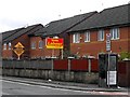
. . . to the bus stop.
By-electioneering on Entwistle Road
Image: © Peter Thwaite
Taken: 24 Feb 2024
0.14 miles
6
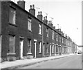
Ramsay Street, Rochdale, Lancashire
Showing the north side of the street, east of the junction with Bulwer Street. It can be seen that some of these houses were life-expired in 1979 when this was taken.
Image: © Dr Neil Clifton
Taken: 15 Sep 1979
0.15 miles
8
Electioneering 2010
Political neighbours on Entwistle Street, Wardleworth
Image: © Peter Thwaite
Taken: 1 May 2010
0.16 miles
9
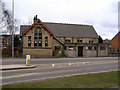
Mission Church of the Good Shepherd
Entwisle Road. (Built 1895)
Image: © David Dixon
Taken: 15 Mar 2010
0.17 miles
10
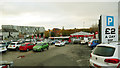
Car park, Molesworth Street, Rochdale
An old map shows there were once terraced houses here, backing onto Berry Street, of which no trace now remains.
Image: © Stephen Craven
Taken: 26 Nov 2018
0.17 miles