IMAGES TAKEN NEAR TO
Oswald Street, ROCHDALE, OL16 2JZ
Introduction
This page details the photographs taken nearby to Oswald Street, OL16 2JZ by members of the Geograph project.
The Geograph project started in 2005 with the aim of publishing, organising and preserving representative images for every square kilometre of Great Britain, Ireland and the Isle of Man.

There are currently over 7.5m images from over14,400 individuals and you can help contribute to the project by visiting https://www.geograph.org.uk
Image Map (Loading...)


Getting Data...Please wait
Leaflet Map data © OpenStreetMap
Images are licensed for reuse under creativecommons.org/licenses/by-sa/2.0
Notes
- Clicking on the map will re-center to the selected point.
- The higher the marker number, the further away the image location is from the centre of the postcode.
Image Listing (20 Images Found)
Images are licensed for reuse under creativecommons.org/licenses/by-sa/2.0
Image
Details
Distance
1
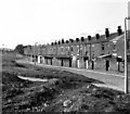
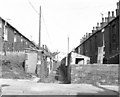
Backs of houses on Oswald Street, Rochdale, Lancashire
The waste ground in the foreground of this photograph is the site of a high railway embankment carrying the L&Y Rochdale to Bacup line. The embankment was removed after the line had closed, shortly before this was taken
Image: © Dr Neil Clifton
Taken: 15 Sep 1979
0.05 miles
3
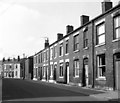
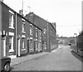
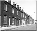
Oswald Street, Rochdale, Lancashire
Many thousands of brick-built terrace homes almost identical with these were built in Rochdale and the other cotton towns of Lancashire, mostly during the late Victorian years. Most of them were rented property when first built.
At the bend in Oswald Street above, Selby Street joins from the right (east).
Image: © Dr Neil Clifton
Taken: 15 Sep 1979
0.06 miles
4
Bulwer Street, Rochdale, Lancashire
Taken from the junction with Corbett Street, (right). At the far end of Bulwer Street is a T-junction with South Street.
Image: © Dr Neil Clifton
Taken: 15 Sep 1979
0.06 miles
5
Corbett Street and Victoria Mill, Rochdale, Lancashire
Taken from the junction with Bulwer Street. The industrial building is the Victoria Mill, originally a cotton waste processing concern, but by 1979 being used for warehousing. At the slight kink in the road, the street name changes to Chestnut Place, which also bends round to the right at the end. The view further on of the house backs only became possible with the removal of the railway embankment, and these houses are on Oswald Street, (centre right) and Entwisle Road (far right).
Image: © Dr Neil Clifton
Taken: 15 Sep 1979
0.06 miles
6
House backs, Ramsay Street and Corbett Street, Rochdale, Lancashire
Looking east from Bulwer Street, this shows the narrow lane dividing the backs of houses on Ramsay Street from those of the next street to the north, Corbett Street. The back lanes were wide enough for a tradesman's barrow, but not for a motor car usually.
Image: © Dr Neil Clifton
Taken: 15 Sep 1979
0.07 miles
7
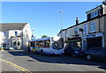
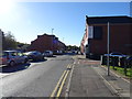
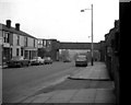
Stuck bus on Entwisle Road
Someones inconsiderate parking was causing traffic chaos.
Image: © JThomas
Taken: 18 Oct 2018
0.08 miles
8
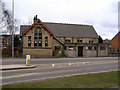
Mission Church of the Good Shepherd
Entwisle Road. (Built 1895)
Image: © David Dixon
Taken: 15 Mar 2010
0.11 miles
9
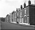
Ramsay Street, Rochdale, Lancashire
Showing the north side of the street, east of the junction with Bulwer Street. It can be seen that some of these houses were life-expired in 1979 when this was taken.
Image: © Dr Neil Clifton
Taken: 15 Sep 1979
0.11 miles
10
Wardleworth Bridge, Yorkshire Street, Rochdale, Lancashire
This was the railway bridge carrying the ex-L.Y.R. Rochdale to Facit branch, which spanned the upper part of Yorkshire Street. Seen here from the west, this bridge was later removed, as the branch line had become completely disused. On the left hand abutment can just be discerned a coat of arms, which was that of the Lancashire and Yorkshire Railway.
Image: © Dr Neil Clifton
Taken: 19 Aug 1970
0.13 miles