IMAGES TAKEN NEAR TO
Robert Street, ROCHDALE, OL16 2DG
Introduction
This page details the photographs taken nearby to Robert Street, OL16 2DG by members of the Geograph project.
The Geograph project started in 2005 with the aim of publishing, organising and preserving representative images for every square kilometre of Great Britain, Ireland and the Isle of Man.

There are currently over 7.5m images from over14,400 individuals and you can help contribute to the project by visiting https://www.geograph.org.uk
Image Map (Loading...)


Getting Data...Please wait
Leaflet Map data © OpenStreetMap
Images are licensed for reuse under creativecommons.org/licenses/by-sa/2.0
Notes
- Clicking on the map will re-center to the selected point.
- The higher the marker number, the further away the image location is from the centre of the postcode.
Image Listing (153 Images Found)
Images are licensed for reuse under creativecommons.org/licenses/by-sa/2.0
Image
Details
Distance
2
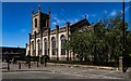
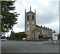
St Mary's Church
St Mary's Ukrainian Roman Catholic Church in Rochdale.
Image: © Peter McDermott
Taken: 25 May 2020
0.06 miles
3
Hopwood Place, off John Street, Rochdale
In 1960s Rochdale, plenty of Dickensian corners could be discovered, as shown by Hopwood Place, above
Image: © Dr Neil Clifton
Taken: 8 Mar 1964
0.07 miles
4
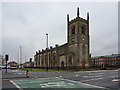
Ukrainian Catholic Church, Rochdale
Clearly not originally used by the denomination now in residence.
Image: © philandju
Taken: 13 Oct 2011
0.07 miles
5
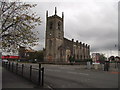
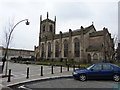
Ukrainian Catholic Church of Saint Mary
The Grade II listed https://historicengland.org.uk/listing/the-list/list-entry/1346258?section=official-list-entry church dates from 1821 and was formerly the Anglican Church of St James. It became a Ukrainian Catholic Church in 1975.
Image: © Gerald England
Taken: 6 Aug 2022
0.07 miles
6
St Mary Ukrainian RC Church, Rochdale
Image: © Alexander P Kapp
Taken: 25 Jan 2010
0.07 miles
7
St Mary Ukrainian RC Church, Rochdale
Image: © Alexander P Kapp
Taken: 25 Jan 2010
0.07 miles
8

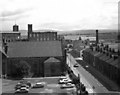
Towards Townhead Mill, Rochdale, Lancashire
Looking north-east from the roof of the car park, the skyline is dominated by the chimney and engine house of Townhead Mill. The more modern metal chimney to the left belongs to Holcroft Engineering. In the middle distance, Penn Street climbs from Baillie Street to Yorkshire Street, with Penn Street School a prominent feature.
Image: © Dr Neil Clifton
Taken: 17 Aug 1978
0.08 miles
9
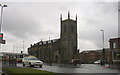
St James' Church
Consecrated in 1821 as an Anglican Church. In 1975 it became a Ukrainian Catholic Church.
Image: © Robert Wade
Taken: 30 Mar 2009
0.08 miles
10
Along Smith Street, Rochdale, Lancashire
Standing at the eastern end of the car park roof, we are looking east along the eastern end of Smith Street towards its junction with John Street (left) and Molesworth Street (right). On the left hand side of Smith Street is the Congregational Church, and behind that, the Vale Woollen Mill. On the extreme left is Jennings cotton Mill.
On the skyline we see the Pennine hills, beyond which lies Yorkshire.
Image: © Dr Neil Clifton
Taken: 17 Aug 1978
0.10 miles