
IMAGES TAKEN NEAR TO
Ramsay Street, ROCHDALE, OL16 2BX
Introduction
This page details the photographs taken nearby to Ramsay Street, OL16 2BX by members of the Geograph project.
The Geograph project started in 2005 with the aim of publishing, organising and preserving representative images for every square kilometre of Great Britain, Ireland and the Isle of Man.

There are currently over 7.5m images from over14,400 individuals and you can help contribute to the project by visiting https://www.geograph.org.uk
Image Map
Images are licensed for reuse under creativecommons.org/licenses/by-sa/2.0
Notes
- Clicking on the map will re-center to the selected point.
- The higher the marker number, the further away the image location is from the centre of the postcode.
Image Listing (42 Images Found)
Images are licensed for reuse under creativecommons.org/licenses/by-sa/2.0
Image
Details
Distance
1

Jalalia Jame mosque, Rochdale
This mosque, situated off Entwistle Rd, is in the heart of one of Rochdale's Bangladeshi communities.
Image: © michael ely
Taken: 25 Nov 2005
0.02 miles
2
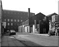
West end of Ramsay Street, Rochdale, Lancashire
This shows the end of Ramsay Street where it makes a T-junction with George Street. On the right is a mineral water factory, and across the end, actually on George Street, is the five-storey Jennings Mill (cotton and cotton waste).
Image: © Dr Neil Clifton
Taken: 15 Sep 1979
0.06 miles
3

. . . to the bus stop.
By-electioneering on Entwistle Road
Image: © Peter Thwaite
Taken: 24 Feb 2024
0.12 miles
4
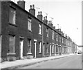
Ramsay Street, Rochdale, Lancashire
Showing the north side of the street, east of the junction with Bulwer Street. It can be seen that some of these houses were life-expired in 1979 when this was taken.
Image: © Dr Neil Clifton
Taken: 15 Sep 1979
0.14 miles
6
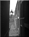
Hopwood Place, off John Street, Rochdale
In 1960s Rochdale, plenty of Dickensian corners could be discovered, as shown by Hopwood Place, above
Image: © Dr Neil Clifton
Taken: 8 Mar 1964
0.16 miles
7
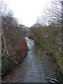
River Roch from John Street bridge
Image: © Alexander P Kapp
Taken: 25 Jan 2010
0.16 miles
8
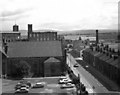
Along Smith Street, Rochdale, Lancashire
Standing at the eastern end of the car park roof, we are looking east along the eastern end of Smith Street towards its junction with John Street (left) and Molesworth Street (right). On the left hand side of Smith Street is the Congregational Church, and behind that, the Vale Woollen Mill. On the extreme left is Jennings cotton Mill.
On the skyline we see the Pennine hills, beyond which lies Yorkshire.
Image: © Dr Neil Clifton
Taken: 17 Aug 1978
0.16 miles
9
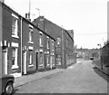
Corbett Street and Victoria Mill, Rochdale, Lancashire
Taken from the junction with Bulwer Street. The industrial building is the Victoria Mill, originally a cotton waste processing concern, but by 1979 being used for warehousing. At the slight kink in the road, the street name changes to Chestnut Place, which also bends round to the right at the end. The view further on of the house backs only became possible with the removal of the railway embankment, and these houses are on Oswald Street, (centre right) and Entwisle Road (far right).
Image: © Dr Neil Clifton
Taken: 15 Sep 1979
0.17 miles
10
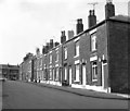
Bulwer Street, Rochdale, Lancashire
Taken from the junction with Corbett Street, (right). At the far end of Bulwer Street is a T-junction with South Street.
Image: © Dr Neil Clifton
Taken: 15 Sep 1979
0.17 miles