IMAGES TAKEN NEAR TO
Chichester Street, ROCHDALE, OL16 2AX
Introduction
This page details the photographs taken nearby to Chichester Street, OL16 2AX by members of the Geograph project.
The Geograph project started in 2005 with the aim of publishing, organising and preserving representative images for every square kilometre of Great Britain, Ireland and the Isle of Man.

There are currently over 7.5m images from over14,400 individuals and you can help contribute to the project by visiting https://www.geograph.org.uk
Image Map
Images are licensed for reuse under creativecommons.org/licenses/by-sa/2.0
Notes
- Clicking on the map will re-center to the selected point.
- The higher the marker number, the further away the image location is from the centre of the postcode.
Image Listing (66 Images Found)
Images are licensed for reuse under creativecommons.org/licenses/by-sa/2.0
Image
Details
Distance
2
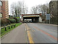
Milnrow Road (A640), Rochdale
Looking south-eastwards under bridges that enable trams and trains to cross the road.
Image: © Peter Wood
Taken: 7 Feb 2023
0.06 miles
3
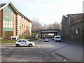
Milnrow Road
With new offices on one side and on the other, old industrial buildings
Image: © Alexander P Kapp
Taken: 13 Feb 2009
0.07 miles
4
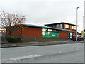
Springhill Emporium, Molesworth Street, Rochdale
Despite the fancy title, this is a charity shop for the Springhill Hospice.
Image: © Stephen Craven
Taken: 26 Nov 2018
0.08 miles
5
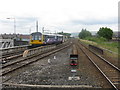
Leaving for Leeds
A local service heads north from Rochdale station.
Image: © Peter Whatley
Taken: 24 Jul 2013
0.08 miles
6
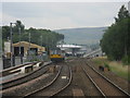
The new view north from Rochdale station
Compare with the view from the other side of the station here: http://www.geograph.org.uk/photo/2238930.
Image: © Peter Whatley
Taken: 24 Jul 2013
0.10 miles
7
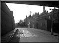
Moss Lane, Rochdale, Lancashire
This dingy street runs roughly parallel to Oldham Road, and its name suggests that it may actually be on the alignment of the original route to Oldham.
Image: © Dr Neil Clifton
Taken: 8 Mar 1964
0.10 miles
8
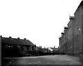
Railway grain warehouse and stables, Rochdale, Lancashire
In 1951 when this photograph was taken, goods traffic was collected and delivered using horse drays, and some of these can be discerned at the end of the yard. The building on the left is the stables, it lasted until 1957 by which time motorised transport had replaced the horses. The grain warehouse on the right lasted a few more years.
Image: © Dr Neil Clifton
Taken: 25 Mar 1951
0.10 miles
10
Molesworth Street, Rochdale
In this rather grim photograph, across from Molesworth Street in Rochdale, is a piece of industrial wasteland cum car park. One of the more uglier parts of Rochdale, but sadly common in many of the post-industrial towns of Greater Manchester and North West England.
Image: © Steven Haslington
Taken: 6 Jun 2011
0.11 miles