IMAGES TAKEN NEAR TO
The Wheatsheaf Centre, ROCHDALE, OL16 1JZ
Introduction
This page details the photographs taken nearby to The Wheatsheaf Centre, OL16 1JZ by members of the Geograph project.
The Geograph project started in 2005 with the aim of publishing, organising and preserving representative images for every square kilometre of Great Britain, Ireland and the Isle of Man.

There are currently over 7.5m images from over14,400 individuals and you can help contribute to the project by visiting https://www.geograph.org.uk
Image Map (Loading...)


Getting Data...Please wait
Leaflet Map data © OpenStreetMap
Images are licensed for reuse under creativecommons.org/licenses/by-sa/2.0
Notes
- Clicking on the map will re-center to the selected point.
- The higher the marker number, the further away the image location is from the centre of the postcode.
Image Listing (443 Images Found)
Images are licensed for reuse under creativecommons.org/licenses/by-sa/2.0
Image
Details
Distance
1
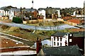
Site of the Wheatsheaf Centre
Preparatory land clearance before the construction of the Wheatsheaf Centre
Image: © Bryan Tenny
Taken: Unknown
0.01 miles
2
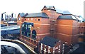
The Wheatsheaf Shopping Centre
A shopping 'mall' constructed between 1988-1990.
Image: © Bryan Tenny
Taken: Unknown
0.02 miles
3
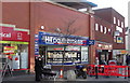
"H & T Pawnbrokers" 92, Yorkshire Street, Rochdale, Lancashire OL16 1JX
Charity shops and pawnbrokers seem to be the future
Image: © Robert Wade
Taken: 29 Jan 2011
0.02 miles
4
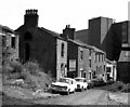
Acker Street, Rochdale, Lancashire
Acker Street had become virtually a slum before its demolition in the late 1970s.
Image: © Dr Neil Clifton
Taken: 18 Aug 1977
0.03 miles

6
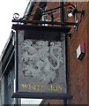
Sign of The White Lion
Sign for The White Lion Image
Image: © Gerald England
Taken: 6 Aug 2022
0.04 miles
7
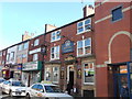
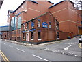
Thwaites "White Lion Hotel" (Pub) 102 Yorkshire Street, Rochdale OL16 1JY
Image: © Robert Wade
Taken: 29 Jan 2011
0.04 miles
8
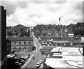
Looking up Penn Street, Rochdale, Lancashire
Here we have moved westward along the car park roof and are looking straight up Penn Street, with the former Penn Street Infants School prominent on the right. The building of ecclesiastical appearance on the left was originally a Sunday school, while the flat roof (right foreground) belongs to the Baillie Street Health Centre.
Image: © Dr Neil Clifton
Taken: 17 Aug 1978
0.04 miles
9
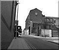
Penn Street, Rochdale, Lancashire
This steep street runs up from Smith Street, crosses Baillie Street, and meets Yorkshire Street in a T-junction.
Image: © Dr Neil Clifton
Taken: 22 Jul 1996
0.04 miles
10
Bar Vegas, Baillie Street, Rochdale
Image: © Alexander P Kapp
Taken: 25 Jan 2010
0.04 miles