IMAGES TAKEN NEAR TO
Oak Street, ROCHDALE, OL16 1FD
Introduction
This page details the photographs taken nearby to Oak Street, OL16 1FD by members of the Geograph project.
The Geograph project started in 2005 with the aim of publishing, organising and preserving representative images for every square kilometre of Great Britain, Ireland and the Isle of Man.

There are currently over 7.5m images from over14,400 individuals and you can help contribute to the project by visiting https://www.geograph.org.uk
Image Map (Loading...)


Getting Data...Please wait
Leaflet Map data © OpenStreetMap
Images are licensed for reuse under creativecommons.org/licenses/by-sa/2.0
Notes
- Clicking on the map will re-center to the selected point.
- The higher the marker number, the further away the image location is from the centre of the postcode.
Image Listing (520 Images Found)
Images are licensed for reuse under creativecommons.org/licenses/by-sa/2.0
Image
Details
Distance
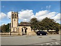
1
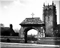
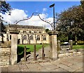
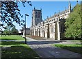
Rochdale: Parish Church of St. Chad and lychgate
The church, parts of which date from Norman times, stands in an imposing position above the Town Centre.
Image: © Dr Neil Clifton
Taken: 27 Mar 1951
0.03 miles
2
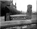
Stocks, Rochdale Parish Church
These stocks, which were installed in 1688, were last used by a local miscreant named Billy Pod in 1822, but I would suggest they might be at least as effective as ASBOs to deter the brainless morons who deface our towns and cities with graffiti.
Image: © Dr Neil Clifton
Taken: 27 Mar 1951
0.03 miles
3
Stocks at St Chad's
The stocks inside the churchyard of St Chad's date from 1688. It is said that they were last used to shackle Billy Pod in 1822. The entrance on Church Stile leads to a path around the east end of the church and on to Church Steps.
Image: © Gerald England
Taken: 22 Sep 2016
0.04 miles
4
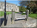
Rochdale, stocks
In the churchyard of St. Chad's. The upper arm appears to be a replacement, but the structure dates from C17. Grade II listed by Historic England: https://historicengland.org.uk/listing/the-list/list-entry/1346246
Image: © Mike Faherty
Taken: 21 Sep 2019
0.04 miles
5
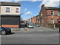
Rochdale: Church Stile
Looking north, towards the Parish Church. Behind the wall on the left is an old burial ground, which has been grassed over making a pleasant space.
Image: © Dr Neil Clifton
Taken: 18 Mar 2011
0.04 miles
6
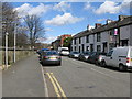
Rochdale: Moore Street
Looking from is junction with Drake Street. Rochdale Town Hall is just visible in the distance.
Image: © Dr Neil Clifton
Taken: 18 Mar 2011
0.04 miles
7
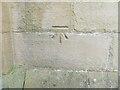
Ordnance Survey Cut Mark
This mark can be found on the wall of St Chad's Church, Rochdale.
The recorded details give a height of 143.0792 metres above sea level.
For more detail see : https://www.bench-marks.org.uk/bm105310
Image: © Peter Wood
Taken: 7 Feb 2023
0.05 miles
8
Rochdale, St. Chad's
Parish church on Church Lane. Dating from C13, the building is Grade II* listed by Historic England: https://historicengland.org.uk/listing/the-list/list-entry/1045812
Image: © Mike Faherty
Taken: 21 Sep 2019
0.05 miles
9
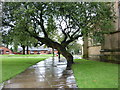
Don't forget to duck
A tree in the grounds of St Chad's Church, Rochdale.
Image: © Ian S
Taken: 20 Sep 2011
0.05 miles
10
St Chad's from Church Stile
St Chad's Parish Church on the top of Sparrow Hill dates from the 12th century. The first incumbent in 1194 was Geoffrey, Dean of Whalley. The church was extensively repaired in 1856 and in 1994 the 800th anniversary was marked with a visit from Her Majesty the Queen and the Duke of Edinburgh.
St Chad to whom Rochdale parish church is dedicated was a 7th century northern churchman who became abbot of Lastingham in Yorkshire, and for a while he was bishop of York until St Wilfrid returned from France. Later, he was made bishop of the Mercians at Lichfield. He died in 672 AD and his feast-day is held on 2nd March.
Image: © Gerald England
Taken: 22 Sep 2016
0.05 miles