IMAGES TAKEN NEAR TO
The Walk, ROCHDALE, OL16 1EP
Introduction
This page details the photographs taken nearby to The Walk, OL16 1EP by members of the Geograph project.
The Geograph project started in 2005 with the aim of publishing, organising and preserving representative images for every square kilometre of Great Britain, Ireland and the Isle of Man.

There are currently over 7.5m images from over14,400 individuals and you can help contribute to the project by visiting https://www.geograph.org.uk
Image Map (Loading...)


Getting Data...Please wait
Leaflet Map data © OpenStreetMap
Images are licensed for reuse under creativecommons.org/licenses/by-sa/2.0
Notes
- Clicking on the map will re-center to the selected point.
- The higher the marker number, the further away the image location is from the centre of the postcode.
Image Listing (505 Images Found)
Images are licensed for reuse under creativecommons.org/licenses/by-sa/2.0
Image
Details
Distance
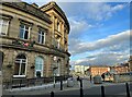
2
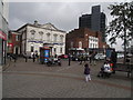
Royal Bank of Scotland, Rochdale
The white building in centre shot is an RBS branch in central Rochdale. The tower block on the right is Council Offices.
Image: © philandju
Taken: 13 Oct 2011
0.01 miles
3
Old Rochdale on display
The former Montague Burton Image store is empty, awaiting new tenants. The ground floor windows are displaying an old map of the town and photographs showing change over time. On the left is seen Rochdale Town Hall.
Image: © Gerald England
Taken: 22 Sep 2016
0.01 miles
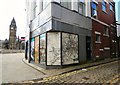
4
Former Montague Burton's
The former Montague Burton store is empty, awaiting new tenants. The ground floor windows are displaying an old map of the town Image and historic photographs.
Image: © Gerald England
Taken: 22 Sep 2016
0.01 miles
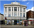
5
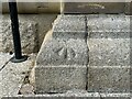
Benchmark, Rochdale, Midland Bank
Detail of an Ordnance Survey pivot benchmark on the granite plinth of the former Midland Bank, now HSBC. The benchmark marks a height of 120.1766m above mean sea level (Ordnance Datum Newlyn) last levelled and verified in 1962 (location photograph Image).
Image: © Adrian Taylor
Taken: 14 Sep 2022
0.01 miles
6
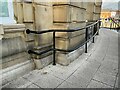
Metal railings
Tubular metal railings have been installed beside a gently sloping ramp leading to the entrance of the former Midland Bank, now HSBC.
There is an Ordnance Survey pivot benchmark on the corner of the stone plinth below the railings (photograph Image).
Image: © Adrian Taylor
Taken: 14 Sep 2022
0.01 miles
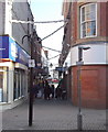
7
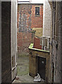
Behind the shops
Looking down an alley off the southern end of Yorkshire Street.
Image: © michael ely
Taken: 23 Feb 2009
0.01 miles
9
Rochdale Town Centre
The building on the left is the former Midland Bank, now HSBC.
There is an Ordnance Survey pivot benchmark on the plinth of the bank building under the suspended HSBC logo sign (photograph Image).
Image: © Adrian Taylor
Taken: 14 Sep 2022
0.02 miles
10
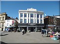
Rochdale, foodhall
Rochdale Market Foodhall, on The Butts. The future of the market sounds limited: https://www.theguardian.com/uk-news/2019/sep/22/rochdale-traders-and-shoppers-despair-at-loss-of-historic-market
Image: © Mike Faherty
Taken: 21 Sep 2019
0.02 miles