IMAGES TAKEN NEAR TO
Roberts Passage, LITTLEBOROUGH, OL15 9RE
Introduction
This page details the photographs taken nearby to Roberts Passage, OL15 9RE by members of the Geograph project.
The Geograph project started in 2005 with the aim of publishing, organising and preserving representative images for every square kilometre of Great Britain, Ireland and the Isle of Man.

There are currently over 7.5m images from over14,400 individuals and you can help contribute to the project by visiting https://www.geograph.org.uk
Image Map
Images are licensed for reuse under creativecommons.org/licenses/by-sa/2.0
Notes
- Clicking on the map will re-center to the selected point.
- The higher the marker number, the further away the image location is from the centre of the postcode.
Image Listing (93 Images Found)
Images are licensed for reuse under creativecommons.org/licenses/by-sa/2.0
Image
Details
Distance
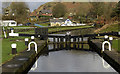
2
Rochdale canal towpath near Lock no 38
Looking north towards Summit.
Image: © michael ely
Taken: 28 Jan 2010
0.04 miles
3
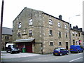
Ex-Independent Ebenezer Chapel, Summit
Now a private house
Image: © Alexander P Kapp
Taken: 30 May 2007
0.04 miles
4
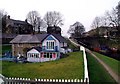
Lower Chelburn, Summit
Colourful house on the west bank of the Rochdale Canal near Chelburn Bridge at Summit.
The Rochdale Canal was completed in 1804 and covers 32 miles with 91 locks between Sowerby Bridge near Halifax and the Castlefield Basin, Manchester. Commercial use of the canal peaked in 1880 at about 50 boats a day but the last loaded barge travelled its full length in 1937 and from then on it fell into disrepair. The canal reopened in 2002 after a few years of refurbishment and is now used almost exclusively for leisure purposes.
Image: © Paul Glazzard
Taken: 12 Apr 2007
0.04 miles
6
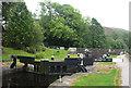
West Summit Lock 37 from above
Rochdale Canal
Image: © Mike Todd
Taken: 15 Jun 2011
0.05 miles
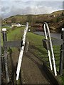
7
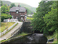
Bridge 42
Rochdale Canal near Calderbrook, immediately below West Summit Lock 39. This lock is normally locked except for booked passages (max 4 per day in each direction) first thing each morning. Resident lock keeper runs an evening shop, useful for boats which have to moor below the lock overnight.
Image: © Mike Todd
Taken: 15 Jun 2011
0.05 miles
9
Lock no 38 Rochdale Canal
Almost at the highest point of the canal's journey. The building in the top left of the picture (partially hidden by trees) is the Summit Inn on the A6033, Todmorden Road.
Image: © michael ely
Taken: 28 Jan 2010
0.05 miles
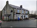
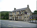
10
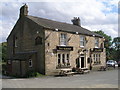
The Summit public house
The summit referred to is that of the nearby Rochdale Canal
Image: © John Slater
Taken: 16 Aug 2012
0.05 miles