IMAGES TAKEN NEAR TO
Cliffe Street, LITTLEBOROUGH, OL15 9RB
Introduction
This page details the photographs taken nearby to Cliffe Street, OL15 9RB by members of the Geograph project.
The Geograph project started in 2005 with the aim of publishing, organising and preserving representative images for every square kilometre of Great Britain, Ireland and the Isle of Man.

There are currently over 7.5m images from over14,400 individuals and you can help contribute to the project by visiting https://www.geograph.org.uk
Image Map
Images are licensed for reuse under creativecommons.org/licenses/by-sa/2.0
Notes
- Clicking on the map will re-center to the selected point.
- The higher the marker number, the further away the image location is from the centre of the postcode.
Image Listing (99 Images Found)
Images are licensed for reuse under creativecommons.org/licenses/by-sa/2.0
Image
Details
Distance
1
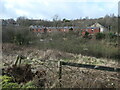
Houses on Cliffe Street, Summit
These red-brick houses were built between 1909 and 1929 on the west bank of the River Roch.
Image: © Christine Johnstone
Taken: 1 Feb 2022
0.00 miles
2
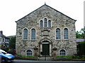
Primitive Methodist Chapel, Summit
Image: © Alexander P Kapp
Taken: 30 May 2007
0.03 miles
3
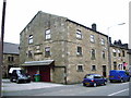
Ex-Independent Ebenezer Chapel, Summit
Now a private house
Image: © Alexander P Kapp
Taken: 30 May 2007
0.04 miles
4
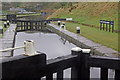
The Keith Parry Lock no 39
Looking south towards Littleborough. The lock is dedicated to a canal enthusiast.
Image: © michael ely
Taken: 28 Jan 2010
0.04 miles
5
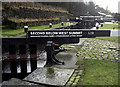
First Below West Summit, Rochdale Canal
This is the penultimate lock before the summit pound is reached at West Summit Lock which is just beyond the bend ahead.
Image: © Stephen McKay
Taken: 30 Mar 2009
0.04 miles
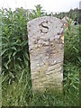
6
Milestone at lock 38, Rochdale Canal
"S14 M18" means 14 miles to the eastern end of the canal at Sowerby Bridge and 18 miles to the western end in Manchester. For a close-up, see Image
Image: © Christine Johnstone
Taken: 1 Feb 2022
0.05 miles
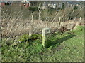
7
Old milemarker by the Rochdale Canal, Summit
Milemarker by the Rochdale Canal, in parish of Littleborough (Rochdale District), Summit (Lancashire), near lock 38, First Below West Summit Lock.
Inscription reads:-
S
14
---
M
18
(To Sowerby Bridge and Manchester)
Surveyed
Milestone Society National ID: RCH-14
Image: © Milestone Society
Taken: Unknown
0.05 miles
8
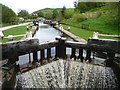
1st below West Summit Lock, Rochdale Canal
High water levels make the water spill over the bottom gates. The top gates are open to let the narrowboat in.
Image: © Christine Johnstone
Taken: 7 May 2014
0.05 miles
9

First below west summit
Lock #38 Rochdale Canal.
Image: © Ian S
Taken: 30 May 2012
0.05 miles
10
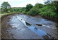
Rochdale Canal below lock 38
Closed to navigation for the time being.
Image: © michael ely
Taken: 29 Jun 2023
0.05 miles