IMAGES TAKEN NEAR TO
Barnes Meadows, LITTLEBOROUGH, OL15 9QE
Introduction
This page details the photographs taken nearby to Barnes Meadows, OL15 9QE by members of the Geograph project.
The Geograph project started in 2005 with the aim of publishing, organising and preserving representative images for every square kilometre of Great Britain, Ireland and the Isle of Man.

There are currently over 7.5m images from over14,400 individuals and you can help contribute to the project by visiting https://www.geograph.org.uk
Image Map
Images are licensed for reuse under creativecommons.org/licenses/by-sa/2.0
Notes
- Clicking on the map will re-center to the selected point.
- The higher the marker number, the further away the image location is from the centre of the postcode.
Image Listing (55 Images Found)
Images are licensed for reuse under creativecommons.org/licenses/by-sa/2.0
Image
Details
Distance
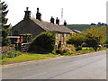
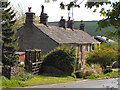
1
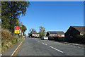
Road closure on Calderbrook Road
Diversion available via the A6033.
Image: © JThomas
Taken: 18 Oct 2018
0.02 miles
6
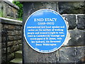
Enid Stacy (1868-1903)
To be found at the side of the gate to St James Church
Image: © Alexander P Kapp
Taken: 30 May 2007
0.05 miles
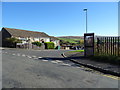
7
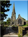
Saint James Calderbrook
The north end of the church viewed from Higher Calderbrook Road.
Image: © Peter Thwaite
Taken: 23 May 2010
0.05 miles
8
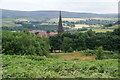
Calderbrook from the Pennine Bridleway
The spire of St James and part of the Stansfield Estate are visible. The Roch valley is beyond.
Image: © Bill Boaden
Taken: 20 Jul 2013
0.05 miles
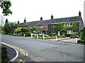
10
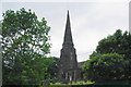
St James, Calderbrook
A very prominent spire but it is not so easy to get a clear view of it close to. This is in the older part of the village before new housing estates were added on.
Image: © Bill Boaden
Taken: 20 Jul 2013
0.06 miles