IMAGES TAKEN NEAR TO
Green Clough, LITTLEBOROUGH, OL15 9PN
Introduction
This page details the photographs taken nearby to Green Clough, OL15 9PN by members of the Geograph project.
The Geograph project started in 2005 with the aim of publishing, organising and preserving representative images for every square kilometre of Great Britain, Ireland and the Isle of Man.

There are currently over 7.5m images from over14,400 individuals and you can help contribute to the project by visiting https://www.geograph.org.uk
Image Map
Images are licensed for reuse under creativecommons.org/licenses/by-sa/2.0
Notes
- Clicking on the map will re-center to the selected point.
- The higher the marker number, the further away the image location is from the centre of the postcode.
Image Listing (95 Images Found)
Images are licensed for reuse under creativecommons.org/licenses/by-sa/2.0
Image
Details
Distance
1
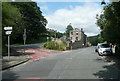
The junction of Barnes Meadows with Todmorden Road, Calderbrook
The road name looks modern, and a look at the 1:2500 map on 1893 shows only a track. The 1910 edition shows the road, without a name, only as far as the newly built school. Calderbrook Terrace also appears on that map.
Image: © Humphrey Bolton
Taken: 24 Jul 2017
0.01 miles
2
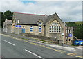
Church of England primary School. Calderbrook. Littleborough
This first appears on the 1910 edition of the 1:2500 map.
Image: © Humphrey Bolton
Taken: 24 Jul 2017
0.08 miles
3
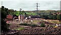
New Reddyshore Brow Housing in 1998
Pile driving was needed on the former mill/chemical works site latterly known as Grove Works
Image: © Kevin Waterhouse
Taken: Unknown
0.10 miles
4
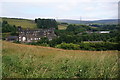
Hillside above Stansfield Hall Primary School
This spot has views across the Roch valley to Sladen Fold.
Image: © Bill Boaden
Taken: 20 Jul 2013
0.10 miles
5
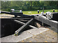
Thickone Lock 43
Rochdale Canal near Calderbrook. Shot shows bracing below bottom gates as well as paddle mechanism which is distinctive of this canal
Image: © Mike Todd
Taken: 14 Jun 2011
0.11 miles
6
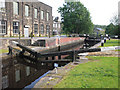
Thickone Lock 43 from above
Rochdale Canal near Calderbrook. Disused mill to left of shot
Image: © Mike Todd
Taken: 14 Jun 2011
0.11 miles
7
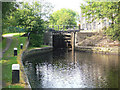
Thickone Lock 43 from below
Rochdale Canal near Calderbrook
Image: © Mike Todd
Taken: 14 Jun 2011
0.11 miles

9
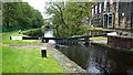
Rochdale Canal Lock No.43
The top gates when the canal is in flood
Image: © Kevin Waterhouse
Taken: 4 Oct 2020
0.11 miles
10
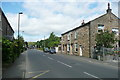
Todmorden Road (A6033) Summit, Littleborough
Image: © Humphrey Bolton
Taken: 24 Jul 2017
0.11 miles