IMAGES TAKEN NEAR TO
Calderbrook Road, LITTLEBOROUGH, OL15 9PG
Introduction
This page details the photographs taken nearby to Calderbrook Road, OL15 9PG by members of the Geograph project.
The Geograph project started in 2005 with the aim of publishing, organising and preserving representative images for every square kilometre of Great Britain, Ireland and the Isle of Man.

There are currently over 7.5m images from over14,400 individuals and you can help contribute to the project by visiting https://www.geograph.org.uk
Image Map
Images are licensed for reuse under creativecommons.org/licenses/by-sa/2.0
Notes
- Clicking on the map will re-center to the selected point.
- The higher the marker number, the further away the image location is from the centre of the postcode.
Image Listing (92 Images Found)
Images are licensed for reuse under creativecommons.org/licenses/by-sa/2.0
Image
Details
Distance
1
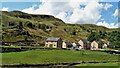
New Housing at Dean Head
Housing built on an old garage site beneath Scout End
Image: © Kevin Waterhouse
Taken: 17 Aug 2017
0.05 miles
2
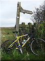
Start of the Mary Towneley Loop
When riding the national trail from south to north the 47-mile Mary Towneley Loop begins here on Calderbrook Road at Summit. The finger post is pointing in the direction of Watergrove.
Image: © michael ely
Taken: 26 Sep 2011
0.05 miles
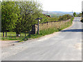
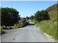
3
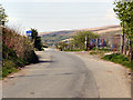
Calderbrook Road
Passing over the Summit tunnel.
Image: © David Dixon
Taken: 18 May 2010
0.05 miles
4
A Four-Legged waterpoint
A little English humour near the Western end of the Summit Level of the Rochdale Canal.
Image: © Howard Selina
Taken: Unknown
0.06 miles
5
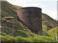
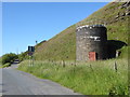
Ventilation Tower
The tower of a ventilation shaft, set into the hillside over the Summit railway tunnel.
Image: © David Dixon
Taken: 18 May 2010
0.06 miles
6
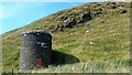
Summit Railway Tunnel Air Shaft No.4
Shaft off Calderbrook Road
Image: © Kevin Waterhouse
Taken: 16 Aug 2016
0.06 miles
7
The Pennine Bridleway Mary Towneley loop near Summit
Image: © Dave Kelly
Taken: 3 Jul 2019
0.07 miles
8
Calderbrook Road
Looking from Reddyshore Scout Gate to the point where the Pennine Bridleway crosses Calderbrook Road.
Image: © David Dixon
Taken: 18 May 2010
0.07 miles
9
The Pennine Bridleway Mary Towneley loop near Summit
Image: © Dave Kelly
Taken: 3 Jul 2019
0.07 miles
10
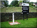
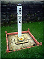
Sign
At the Western Summit on the Rochdale Canal, the white pillar is water tap.
Image: © Alexander P Kapp
Taken: 30 May 2007
0.07 miles