IMAGES TAKEN NEAR TO
Reddyshore Brow, LITTLEBOROUGH, OL15 9PF
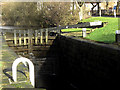
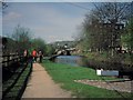
Introduction
This page details the photographs taken nearby to Reddyshore Brow, OL15 9PF by members of the Geograph project.
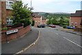
The Geograph project started in 2005 with the aim of publishing, organising and preserving representative images for every square kilometre of Great Britain, Ireland and the Isle of Man.

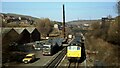
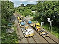
There are currently over 7.5m images from over14,400 individuals and you can help contribute to the project by visiting https://www.geograph.org.uk
Image Map
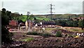
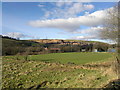
Images are licensed for reuse under creativecommons.org/licenses/by-sa/2.0
Notes
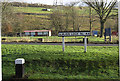
- Clicking on the map will re-center to the selected point.
- The higher the marker number, the further away the image location is from the centre of the postcode.
Image Listing (96 Images Found)
Images are licensed for reuse under creativecommons.org/licenses/by-sa/2.0
Image
Details
Distance
1
New Reddyshore Brow Housing in 1998
Pile driving was needed on the former mill/chemical works site latterly known as Grove Works
Image: © Kevin Waterhouse
Taken: Unknown
0.03 miles
2
Sladen Lock no 44 Rochdale Canal
This lock starts a rise of six locks that follow in very quick succession (locks 44 to 39) as the canal climbs towards its highest point.
Image: © michael ely
Taken: 28 Jan 2010
0.04 miles
3
Aftermath of Summit Railway Tunnel Fire
The imploded railway petrol tankers were being brought out of the tunnel and loaded on road transport. On the left side of the railway in this view there is now a housing estate replacing the works
Image: © Kevin Waterhouse
Taken: Unknown
0.04 miles
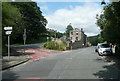
4
Reddyshore Brow
A new housing development off Todmorden Road, with Blackstone Edge in the distance.
Image: © Bill Boaden
Taken: 20 Jul 2013
0.05 miles
5
Railway Contractors
About to start another shift in the Summit railway tunnel from their base at Green Vale Mill
Image: © Kevin Waterhouse
Taken: 16 Jul 2023
0.06 miles
6
Sladen Lock no 44 Rochdale Canal
The lock sign is on the east bank. The low rise building with the white shutters is a cricket pavilion.
Image: © michael ely
Taken: 28 Jan 2010
0.06 miles
7
Littleborough scenery
Fields, houses and Pennine hills occupy the northern reaches of suburban Littleborough, in Greater Manchester, England. The houses in the mid-ground belong to Shottwood Fold.
Image: © Steven Haslington
Taken: 2 Feb 2013
0.06 miles
8
Sladen Fold
The Rochdale Canal at Sladen Fold with mill buildings still in evidence
Image: © David Stowell
Taken: Unknown
0.06 miles
9
The junction of Barnes Meadows with Todmorden Road, Calderbrook
The road name looks modern, and a look at the 1:2500 map on 1893 shows only a track. The 1910 edition shows the road, without a name, only as far as the newly built school. Calderbrook Terrace also appears on that map.
Image: © Humphrey Bolton
Taken: 24 Jul 2017
0.09 miles
10
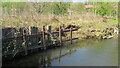
Railway Flood Defences
On Greenvale Brook these rather makeshift defences have at long last been superseded by a huge scheme including diverting the brook
Image: © Kevin Waterhouse
Taken: 24 Apr 2020
0.10 miles