IMAGES TAKEN NEAR TO
Calderbrook Road, LITTLEBOROUGH, OL15 9NR
Introduction
This page details the photographs taken nearby to Calderbrook Road, OL15 9NR by members of the Geograph project.
The Geograph project started in 2005 with the aim of publishing, organising and preserving representative images for every square kilometre of Great Britain, Ireland and the Isle of Man.

There are currently over 7.5m images from over14,400 individuals and you can help contribute to the project by visiting https://www.geograph.org.uk
Image Map
Images are licensed for reuse under creativecommons.org/licenses/by-sa/2.0
Notes
- Clicking on the map will re-center to the selected point.
- The higher the marker number, the further away the image location is from the centre of the postcode.
Image Listing (45 Images Found)
Images are licensed for reuse under creativecommons.org/licenses/by-sa/2.0
Image
Details
Distance
1
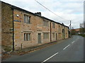
Handle Hall and Barn, Calderbrook Road, Littleborough
Built in 1610 and rebuilt in 1829. The barn was added in the 1840s. See also Image
Image: © Humphrey Bolton
Taken: 2 Nov 2017
0.00 miles
2
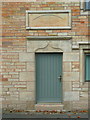
Doorway and datestone, Handle Hall, Calderbrook Road
The house was built in 1610 for Richard Dearden and rebuilt in 1829. It is listed, Grade II.
Image: © Humphrey Bolton
Taken: 2 Nov 2017
0.01 miles
3
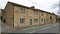
Handle Hall and Barn
On Calderbrook Road
Image: © Kevin Waterhouse
Taken: 22 May 2017
0.01 miles
4
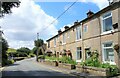
Cottages at Handle Hall
On Calderbrook Road
Image: © michael ely
Taken: 4 Jul 2023
0.01 miles
5
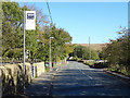
Bus stop on Calderbrook Road, Littleborough
Image: © JThomas
Taken: 18 Oct 2018
0.05 miles
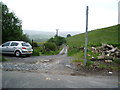
7
Track (footpath) off Calderbrook Road
Towards Whitfield.
Image: © JThomas
Taken: 18 Oct 2018
0.06 miles