IMAGES TAKEN NEAR TO
Calderbrook Road, LITTLEBOROUGH, OL15 9NA
Introduction
This page details the photographs taken nearby to Calderbrook Road, OL15 9NA by members of the Geograph project.
The Geograph project started in 2005 with the aim of publishing, organising and preserving representative images for every square kilometre of Great Britain, Ireland and the Isle of Man.

There are currently over 7.5m images from over14,400 individuals and you can help contribute to the project by visiting https://www.geograph.org.uk
Image Map
Images are licensed for reuse under creativecommons.org/licenses/by-sa/2.0
Notes
- Clicking on the map will re-center to the selected point.
- The higher the marker number, the further away the image location is from the centre of the postcode.
Image Listing (81 Images Found)
Images are licensed for reuse under creativecommons.org/licenses/by-sa/2.0
Image
Details
Distance
1
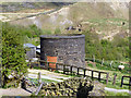
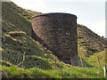
Summit Tunnel Ventilation Tower.
Sheep grazing around one of the ventilation shafts for the Summit tunnel.
Image: © David Dixon
Taken: 18 May 2010
0.04 miles
2
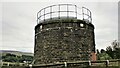
Summit Railway Tunnel Air Shaft No.3
Shaft off Calderbrook Road (Salley Street)
Image: © Kevin Waterhouse
Taken: 6 Aug 2020
0.04 miles
5
View over Summit, Littleborough, Lancashire
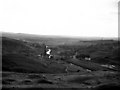
This shows the upper part of the Roch Valley above the village of Summit. Of particular interest is the circular kiln-house of Chelburn Brickworks, already disused, with its central smoke-stack heating all of the kilns equally so that they could be loaded and unloaded in rotation. The Rochdale Canal is prominent as it descends the locks on the western side of the Pennines, with the river and road also being squeezed into the same valley, (the railway here is underground, in Summit Tunnel). The white house centre right is Wilmers, and the outline of the Summit Inn, where once the Todmorden buses met the Rochdale trams, can just be picked out to the left of the road.
Image: © Dr Neil Clifton
Taken: 23 Aug 1966
0.10 miles
6
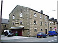
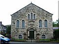
Ex-Independent Ebenezer Chapel, Summit
Now a private house
Image: © Alexander P Kapp
Taken: 30 May 2007
0.11 miles
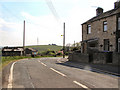
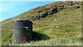
7
Ventilation Tower
The tower of a ventilation shaft, set into the hillside over the Summit railway tunnel.
Image: © David Dixon
Taken: 18 May 2010
0.11 miles
8
Summit Railway Tunnel Air Shaft No.4
Shaft off Calderbrook Road
Image: © Kevin Waterhouse
Taken: 16 Aug 2016
0.11 miles
9
Primitive Methodist Chapel, Summit
Image: © Alexander P Kapp
Taken: 30 May 2007
0.12 miles
10
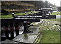
The Keith Parry Lock no 39
Looking south towards Littleborough. The lock is dedicated to a canal enthusiast.
Image: © michael ely
Taken: 28 Jan 2010
0.12 miles