IMAGES TAKEN NEAR TO
Mill Fold Gardens, LITTLEBOROUGH, OL15 8SA
Introduction
This page details the photographs taken nearby to Mill Fold Gardens, OL15 8SA by members of the Geograph project.
The Geograph project started in 2005 with the aim of publishing, organising and preserving representative images for every square kilometre of Great Britain, Ireland and the Isle of Man.

There are currently over 7.5m images from over14,400 individuals and you can help contribute to the project by visiting https://www.geograph.org.uk
Image Map
Images are licensed for reuse under creativecommons.org/licenses/by-sa/2.0
Notes
- Clicking on the map will re-center to the selected point.
- The higher the marker number, the further away the image location is from the centre of the postcode.
Image Listing (34 Images Found)
Images are licensed for reuse under creativecommons.org/licenses/by-sa/2.0
Image
Details
Distance
1
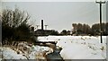
Weir on River Roch in 1991
In the background is Spenwood Works, which has no been replaced by a housing eastate
Image: © Kevin Waterhouse
Taken: Unknown
0.04 miles
2
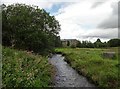
River Roch
Swollen by recent storms. Looking NE from the metal footbridge.
Image: © michael ely
Taken: 26 Aug 2020
0.06 miles
3
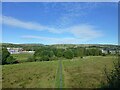
Footpath at Dearnley
View from Rochdale to Leeds railway
Image: © Raymond Knapman
Taken: 6 Oct 2021
0.09 miles
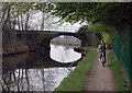
4
Bridge over the Rochdale Canal
This bridge carries a footpath over Brown Brow Hill towards Hollingworth Lake.
Image: © michael ely
Taken: 14 May 2014
0.11 miles
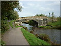
5
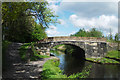
Brown Bank Bridge, Rochdale Canal, Littleborough
Sometimes referred to as Heald Lane Bridge. It carries a minor track unsuitable for motor vehicles.
Image: © Dr Neil Clifton
Taken: 29 Sep 2002
0.11 miles
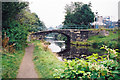
7
The Rochdale Canal, Littleborough
Bridge over the Rochdale Canal southwest of Littleborough, on the track leading over Brown Brow Hill to Lake Bank and Hollingworth Lake.
The Rochdale Canal was completed in 1804 and covers 32 miles with 91 locks between Sowerby Bridge near Halifax and the Castlefield Basin, Manchester. Commercial use of the canal peaked in 1880 at about 50 boats a day but the last loaded barge travelled its full length in 1937 and from then on it fell into disrepair. The canal reopened in 2002 after a few years of refurbishment and is now used almost exclusively for leisure purposes.
Image: © Paul Glazzard
Taken: 12 Apr 2007
0.11 miles
8
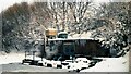
Akzo Site in 1991
This chemical plant has been demolished and the site cleared for housing
Image: © Kevin Waterhouse
Taken: Unknown
0.11 miles
9
Akzo Plant on Rochdale Canal in 1991
The works used canal water for cooling purposes and returned warm water at this building
Image: © Kevin Waterhouse
Taken: Unknown
0.12 miles
10
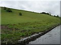
Rochdale Canal bank, south of bridge 52
It looks as if a nature habitat has been created behind the piling, but it may just be bank reinforcement.
Image: © Christine Johnstone
Taken: 7 May 2014
0.13 miles