IMAGES TAKEN NEAR TO
Celandine Close, LITTLEBOROUGH, OL15 8RY
Introduction
This page details the photographs taken nearby to Celandine Close, OL15 8RY by members of the Geograph project.
The Geograph project started in 2005 with the aim of publishing, organising and preserving representative images for every square kilometre of Great Britain, Ireland and the Isle of Man.

There are currently over 7.5m images from over14,400 individuals and you can help contribute to the project by visiting https://www.geograph.org.uk
Image Map
Images are licensed for reuse under creativecommons.org/licenses/by-sa/2.0
Notes
- Clicking on the map will re-center to the selected point.
- The higher the marker number, the further away the image location is from the centre of the postcode.
Image Listing (19 Images Found)
Images are licensed for reuse under creativecommons.org/licenses/by-sa/2.0
Image
Details
Distance
2
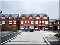
New houses, Springthyme Fold, Littleborough
Image: © Alexander P Kapp
Taken: 30 May 2007
0.15 miles
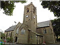
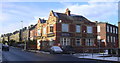
3
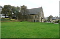
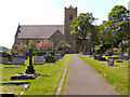
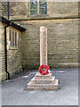
St Barnabas's Church, Shore, Littleborough
A surprisingly large church for a suburb. It was built in 1901 according to Pevsner.
Image: © Humphrey Bolton
Taken: 2 Nov 2017
0.17 miles
8
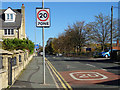
Whitelees Road, Littleborough
Looking north east.
Image: © JThomas
Taken: 18 Oct 2018
0.19 miles
9
"The Sun Hotel" (Pub) 96 Featherstall Road Littleborough OL15 8NY
Image: © Robert Wade
Taken: 27 Nov 2010
0.19 miles
10
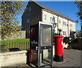
George VI postbox and telephone box on Featherstall Road, Littleborough
Showing position of Postbox No. OL15 55.
See Image] for postbox.
Image: © JThomas
Taken: 18 Oct 2018
0.21 miles