IMAGES TAKEN NEAR TO
Spen Fold, LITTLEBOROUGH, OL15 8JY
Introduction
This page details the photographs taken nearby to Spen Fold, OL15 8JY by members of the Geograph project.
The Geograph project started in 2005 with the aim of publishing, organising and preserving representative images for every square kilometre of Great Britain, Ireland and the Isle of Man.

There are currently over 7.5m images from over14,400 individuals and you can help contribute to the project by visiting https://www.geograph.org.uk
Image Map
Images are licensed for reuse under creativecommons.org/licenses/by-sa/2.0
Notes
- Clicking on the map will re-center to the selected point.
- The higher the marker number, the further away the image location is from the centre of the postcode.
Image Listing (38 Images Found)
Images are licensed for reuse under creativecommons.org/licenses/by-sa/2.0
Image
Details
Distance
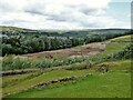
1
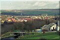
Riverstone Bridge Estate in 1999
The large housing estate was being built in 1999 sandwiched between the River Roch, Rochdale Canal & Railway. Brown Bank canal bridge had railings at this time, since replaced with stone parapets. Lapwings are in the sky
Image: © Kevin Waterhouse
Taken: Unknown
0.03 miles
2
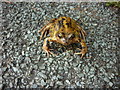
Please don't stand on me
Taken on the tow path of the Rochdale Canal.
Image: © Ian S
Taken: 4 Oct 2011
0.08 miles
3
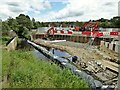
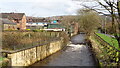
Flood defence works
On the River Roch where the bridge to the housing estate off Stubley Mill Road has been moved by a few yards and the river is being widened and banks piled
Image: © Kevin Waterhouse
Taken: 2 Jul 2023
0.08 miles
4
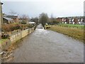
Testing the new flood defences
The River Roch testing the Environment Agency flood defences at the new bridge for Riverstone Bridge after heavy overnight rain.
Image: © Kevin Waterhouse
Taken: 1 Jan 2025
0.08 miles
5
Weir on River Roch
View from the Riverstone estate footbridge
Image: © Kevin Waterhouse
Taken: 20 Mar 2017
0.09 miles
6
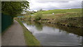
The Rochdale Canal, Hollingworth
The Rochdale Canal in the Hollingworth/Smithybridge area of Littleborough, a suburban town in the Metropolitan Borough of Rochdale, Greater Manchester, England. The hill on the right is Cleggswood Hill.
Image: © Steven Haslington
Taken: 8 May 2012
0.10 miles
7
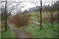
Farfield Community Nature Site
A small area of land adjacent to the Rochdale Canal has been designated as a community nature site. This is looking up towards Hollingworth Road.
Image: © Stephen McKay
Taken: 30 Mar 2009
0.13 miles
8
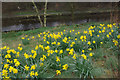
Daffodils by the Rochdale Canal
A small area adjacent to the Rochdale Canal has been designated as the Farfield Community Nature Site. At this time of year it can boast a splendid display of daffodils.
Image: © Stephen McKay
Taken: 30 Mar 2009
0.14 miles
9
New earthworks on brown field site
The former chemical works site by the side of the Rochdale Canal has been allocated for housing for many years. This appears to be a more determined effort to develop the land
Image: © Kevin Waterhouse
Taken: 2 Jul 2023
0.15 miles
10
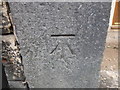
OS Cut Benchmark, 47 Hollingworth Road, Littleborough
Details at https://www.bench-marks.org.uk/bm104382
Image: © Stephen Armstrong
Taken: 21 Oct 2018
0.15 miles