IMAGES TAKEN NEAR TO
LITTLEBOROUGH, OL15 0LR
Introduction
This page details the photographs taken nearby to OL15 0LR by members of the Geograph project.
The Geograph project started in 2005 with the aim of publishing, organising and preserving representative images for every square kilometre of Great Britain, Ireland and the Isle of Man.

There are currently over 7.5m images from over14,400 individuals and you can help contribute to the project by visiting https://www.geograph.org.uk
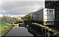
Image Map
Images are licensed for reuse under creativecommons.org/licenses/by-sa/2.0
Notes
- Clicking on the map will re-center to the selected point.
- The higher the marker number, the further away the image location is from the centre of the postcode.
Image Listing (112 Images Found)
Images are licensed for reuse under creativecommons.org/licenses/by-sa/2.0
Image
Details
Distance
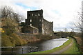
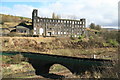
1
Mills at Rock Nook
There is the multi-storey Rock Nook mill and the single storey mill with northern light roof Back I'Th Hole. The latter is the site of the original Fothergill & Harvey mill, built in the mid 19th century.
Image: © Kevin Waterhouse
Taken: 17 Oct 2017
0.01 miles
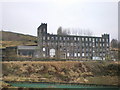
2
Rock Nook Mill
View over the weaving shed roof towards the engine house that probably powered the shed.
Image: © Chris Allen
Taken: 4 Apr 2009
0.02 miles
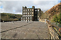
3
Rock Nook Mill. Littleborough, Lancashire
This splendid stone-built mill was built to last, and so far it has resisted everything the Pennine weather and the land-development bean counters can throw at it. It looks good for many more years yet.
Image: © Dr Neil Clifton
Taken: 23 Aug 2006
0.02 miles
4
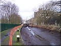
Rochdale Canal drained for repair at Thikone Lock
Image: © Raymond Knapman
Taken: 26 Jan 2012
0.02 miles
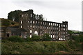
5
Rock Nook Mill
This is at one end of a large contiguous complex extending out of sight to the right. There is a large internal engine house at the left end and an external engine house at the right hand edge of the large block. I suspect this latter powered the single storey shed to its right. I will post some less common views in due course. I've wanted to photograph this since it first appeared on Geograph and i wasn't disappointed.
Image: © Chris Allen
Taken: 4 Apr 2009
0.02 miles
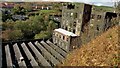
6
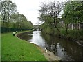
Pound between Locks 42 and 43, Rochdale Canal
High water levels are creating a waterfall over the bottom gates of Lock 42 [second below Punchbowl].
Image: © Christine Johnstone
Taken: 7 May 2014
0.02 miles
8
Greenvale Top Lock no 42 Rochdale Canal
Looking north towards Summit. The mill at right of shot is one of many canal-side on this stretch of the Rochdale Canal.
Image: © michael ely
Taken: 28 Jan 2010
0.02 miles
9
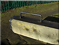
Greenvale Top Lock no 42 Rochdale Canal
Unusually, the name and number of the lock have been written on the lock gate arm. Most other locks have the number stencilled in black on a white background.
Image: © michael ely
Taken: 28 Jan 2010
0.03 miles