IMAGES TAKEN NEAR TO
Gatehouse, Blackstone Edge Old Road, LITTLEBOROUGH, OL15 0JJ
Introduction
This page details the photographs taken nearby to Gatehouse, Blackstone Edge Old Road, OL15 0JJ by members of the Geograph project.
The Geograph project started in 2005 with the aim of publishing, organising and preserving representative images for every square kilometre of Great Britain, Ireland and the Isle of Man.

There are currently over 7.5m images from over14,400 individuals and you can help contribute to the project by visiting https://www.geograph.org.uk
Image Map
Images are licensed for reuse under creativecommons.org/licenses/by-sa/2.0
Notes
- Clicking on the map will re-center to the selected point.
- The higher the marker number, the further away the image location is from the centre of the postcode.
Image Listing (9 Images Found)
Images are licensed for reuse under creativecommons.org/licenses/by-sa/2.0
Image
Details
Distance
3
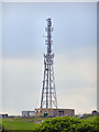
Telecommunications Mast
Mast at the side of Blackstone Edge Old Road.
Image: © David Dixon
Taken: 21 May 2010
0.18 miles
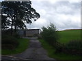
4
Fielden Farm
Viewed from near Shore Lane Farm
Image: © Kevin Waterhouse
Taken: 20 Mar 2016
0.20 miles
5
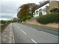
Wide cycle lane on the A58 leaving Littleborough
The lane is wider than usual all the way up to the top of the pass.
Image: © Humphrey Bolton
Taken: 2 Nov 2017
0.20 miles
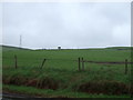
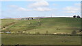
6

Fielden, above Whittaker golf course
Looking north from a public footpath crossing the golf course. Two public footpaths cross at the hilltop farm.
Image: © Christine Johnstone
Taken: 1 Feb 2022
0.20 miles
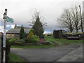
7
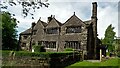
Windy Bank Grade II* Listed Building
The Main House Range has a 1635 dated stone
Image: © Kevin Waterhouse
Taken: 23 May 2017
0.21 miles