IMAGES TAKEN NEAR TO
Halifax Road, LITTLEBOROUGH, OL15 0JG
Introduction
This page details the photographs taken nearby to Halifax Road, OL15 0JG by members of the Geograph project.
The Geograph project started in 2005 with the aim of publishing, organising and preserving representative images for every square kilometre of Great Britain, Ireland and the Isle of Man.

There are currently over 7.5m images from over14,400 individuals and you can help contribute to the project by visiting https://www.geograph.org.uk
Image Map
Images are licensed for reuse under creativecommons.org/licenses/by-sa/2.0
Notes
- Clicking on the map will re-center to the selected point.
- The higher the marker number, the further away the image location is from the centre of the postcode.
Image Listing (43 Images Found)
Images are licensed for reuse under creativecommons.org/licenses/by-sa/2.0
Image
Details
Distance
1
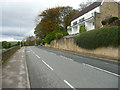
Wide cycle lane on the A58 leaving Littleborough
The lane is wider than usual all the way up to the top of the pass.
Image: © Humphrey Bolton
Taken: 2 Nov 2017
0.12 miles
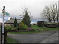
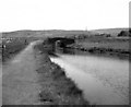
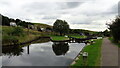
3
Old loading bay on the Rochdale Canal, just above Bent House Lock
Image: © Christine Johnstone
Taken: 17 Mar 2009
0.16 miles
4
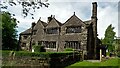
Windy Bank Grade II* Listed Building
The Main House Range has a 1635 dated stone
Image: © Kevin Waterhouse
Taken: 23 May 2017
0.17 miles
5
Windy Bank Bridge, Rochdale Canal, Littleborough, Lancashire
This shows the Rochdale Canal in the time before restoration. The lock that is visible through the bridge is Bent House Lock No.46.
Image: © Dr Neil Clifton
Taken: 30 May 1974
0.17 miles
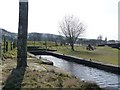
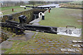
6
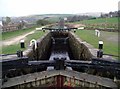
Bent House Lock
Bent House Lock No.46 on the Rochdale Canal northeast of Littleborough.
The Rochdale Canal was completed in 1804 and covers 32 miles with 91 locks between Sowerby Bridge near Halifax and the Castlefield Basin, Manchester. Commercial use of the canal peaked in 1880 at about 50 boats a day but the last loaded barge travelled its full length in 1937 and from then on it fell into disrepair. The canal reopened in 2002 after a few years of refurbishment and is now used almost exclusively for leisure purposes.
Image: © Paul Glazzard
Taken: 12 Apr 2007
0.17 miles
7
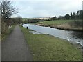
The Rochdale Canal near the site of Windy Bank wharf
Immediately above Bent House lock [no 46]. The wharf was on the non-towpath side.
Image: © Christine Johnstone
Taken: 1 Feb 2022
0.17 miles
8
Bent House Lock no 46 Rochdale Canal
Looking north towards Summit.
Image: © michael ely
Taken: 28 Jan 2010
0.17 miles
9
Canal Wharf at Lock No.46
On the Rochdale canal
Image: © Kevin Waterhouse
Taken: 20 Sep 2016
0.17 miles
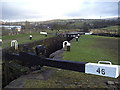
10
Bent House Lock, Rochdale Canal
This is lock no. 46, above Littleborough, as the canal climbs to the summit at Summit.
Image: © Stephen McKay
Taken: 30 Mar 2009
0.17 miles