IMAGES TAKEN NEAR TO
Rake Terrace, LITTLEBOROUGH, OL15 0HY
Introduction
This page details the photographs taken nearby to Rake Terrace, OL15 0HY by members of the Geograph project.
The Geograph project started in 2005 with the aim of publishing, organising and preserving representative images for every square kilometre of Great Britain, Ireland and the Isle of Man.

There are currently over 7.5m images from over14,400 individuals and you can help contribute to the project by visiting https://www.geograph.org.uk
Image Map
Images are licensed for reuse under creativecommons.org/licenses/by-sa/2.0
Notes
- Clicking on the map will re-center to the selected point.
- The higher the marker number, the further away the image location is from the centre of the postcode.
Image Listing (92 Images Found)
Images are licensed for reuse under creativecommons.org/licenses/by-sa/2.0
Image
Details
Distance
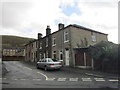
1
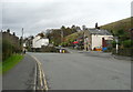
Junction of the A58 with Blackstone Edge Old Road, Littleborough
Image: © Humphrey Bolton
Taken: 2 Nov 2017
0.02 miles
2
The Rake Tapas Restaurant on Blackstone Edge Old Road
Image: © Ian S
Taken: 19 Jan 2012
0.03 miles
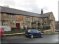
3
The Rake Inn, Blackstone Edge Old Road, Littleborough
The building is listed, Grade II, and the old part is dated 1690. The inn is now a Mediterranean tapas restaurant.
Image: © Humphrey Bolton
Taken: 2 Nov 2017
0.03 miles
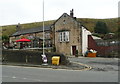
6
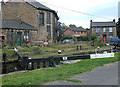
Durn, Littleborough
This is Littleborough Higher Lock number 47 on the outskirts of the town where the A58 crosses the canal. Durn is a hamlet within the township of Littleborough that has sustained a community since mesolithic times.
Image: © michael ely
Taken: 7 Oct 2007
0.08 miles
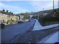
7
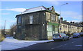
Shop, Halifax Road, Littleborough
AD1905, looks like a former Co Op to me
Image: © Robert Wade
Taken: 27 Nov 2010
0.08 miles
8
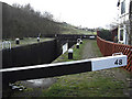
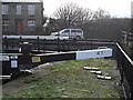
Littleborough Bottom Lock no 48 Rochdale Canal
Looking south towards Ben Healey Bridge. This lock is the lowest of a series of eleven locks that drop the Rochdale Canal into Littleborough from Summit (the canal's highest point) about one mile away.
Image: © michael ely
Taken: 28 Jan 2010
0.09 miles
9
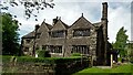
Windy Bank Grade II* Listed Building
The Main House Range has a 1635 dated stone
Image: © Kevin Waterhouse
Taken: 23 May 2017
0.09 miles
10
Littleborough Top Lock no 47 Rochdale Canal
Located just to the north of the A58 Halifax Road at Durn on the outskirts of Littleborough. The white car is crossing the canal on the A58.
Image: © michael ely
Taken: 28 Jan 2010
0.09 miles