IMAGES TAKEN NEAR TO
Smithy Bridge Road, LITTLEBOROUGH, OL15 0DB
Introduction
This page details the photographs taken nearby to Smithy Bridge Road, OL15 0DB by members of the Geograph project.
The Geograph project started in 2005 with the aim of publishing, organising and preserving representative images for every square kilometre of Great Britain, Ireland and the Isle of Man.

There are currently over 7.5m images from over14,400 individuals and you can help contribute to the project by visiting https://www.geograph.org.uk
Image Map
Images are licensed for reuse under creativecommons.org/licenses/by-sa/2.0
Notes
- Clicking on the map will re-center to the selected point.
- The higher the marker number, the further away the image location is from the centre of the postcode.
Image Listing (51 Images Found)
Images are licensed for reuse under creativecommons.org/licenses/by-sa/2.0
Image
Details
Distance
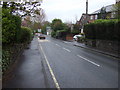
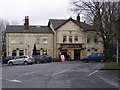
3
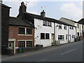
Smithy Bridge Road - 18th century houses
The white building is dated 1788.
Image: © Peter Whatley
Taken: 25 Mar 2011
0.07 miles
6
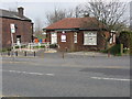
Smithy Bridge library
Delightfully diminutive.
Image: © Peter Whatley
Taken: 25 Mar 2011
0.08 miles
8
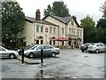
The Beach, Hollingworth
Hollingworth has developed into an inland seaside town.
Image: © Humphrey Bolton
Taken: 26 Jul 2010
0.09 miles
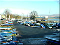
10
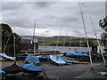
Boatyard, Hollingworth Lake
Looking east across the lake towards Blackstone Edge on the skyline 2½ miles away.
Image: © michael ely
Taken: 20 Sep 2007
0.11 miles