IMAGES TAKEN NEAR TO
Old Bank View, OLDHAM, OL1 4QF
Introduction
This page details the photographs taken nearby to Old Bank View, OL1 4QF by members of the Geograph project.
The Geograph project started in 2005 with the aim of publishing, organising and preserving representative images for every square kilometre of Great Britain, Ireland and the Isle of Man.

There are currently over 7.5m images from over14,400 individuals and you can help contribute to the project by visiting https://www.geograph.org.uk
Image Map
Images are licensed for reuse under creativecommons.org/licenses/by-sa/2.0
Notes
- Clicking on the map will re-center to the selected point.
- The higher the marker number, the further away the image location is from the centre of the postcode.
Image Listing (13 Images Found)
Images are licensed for reuse under creativecommons.org/licenses/by-sa/2.0
Image
Details
Distance
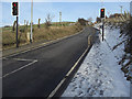
1
Cop Road Sholver
Approaching the steepest section of the road as it climbs out of the Beal Valley. The houses are the start of Bottom Sholver where the road is marked by a chevron on the OS 1/50,000 map.
Image: © michael ely
Taken: 22 Feb 2010
0.01 miles
2
Bottom Sholver
Looking northeast up Cop Road at the western end of Sholver's refurbished housing estate. At the time this photo was taken Cop Road was closed for repairs.
Image: © michael ely
Taken: 25 Feb 2007
0.04 miles
3
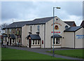
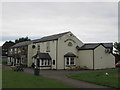
The Northgate, Sholver
This is the main estate pub situated on Sholver Green.
Image: © michael ely
Taken: 25 Feb 2007
0.14 miles
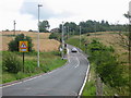
4
Cop Road Sholver
This is the start of a steep climb to Sholver. The phasing of the traffic lights isn't very sympathetic to cyclists. To see the Traffic lights in a wider context and read about their installation click here http://www.geograph.org.uk/photo/496249
Image: © michael ely
Taken: 22 Feb 2010
0.14 miles
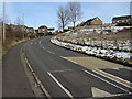
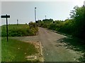
5
Cop Road Sholver
Until recently this narrow single track lane was a real bottle neck with cars having to reverse out of the way to oncoming traffic.
To solve this problem in June 2007 Oldham Council installed traffic lights on the single track section and also erected brand new street lighting on what was once a previously unlit road at night.
Image: © Paul Anderson
Taken: 16 Jul 2007
0.15 miles
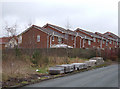
6
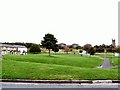
Sholver Green
The original Sholver estate was a concrete jungle of flats and maisonettes, and acquired a reputation as a no-go area. Most of the old estate was demolished and now has been rebuilt with modern housing and better, more open aspects.
Image: © Roger May
Taken: 10 Oct 2005
0.18 miles
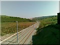
9
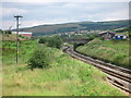
Oldham to Rochdale Railway
This is a section of the Oldham to Rochdale railway line that is soon to be converted into light rail
This is part of the latest Manchester Metrolink network construction programme http://www.metrolink.co.uk/
Image: © Paul Anderson
Taken: 16 Jul 2007
0.23 miles